Tongue End
| Tongue End | |
 Tongue End | |
| Population | 41 |
|---|---|
| OS grid reference | TF161187 |
| - London | 90 mi (140 km) S |
| Civil parish | Deeping St. Nicholas |
| District | South Holland |
| Shire county | Lincolnshire |
| Region | East Midlands |
| Country | England |
| Sovereign state | United Kingdom |
| Post town | SPALDING |
| Postcode district | PE11 |
| Dialling code | 01775 |
| Police | Lincolnshire |
| Fire | Lincolnshire |
| Ambulance | East Midlands |
| EU Parliament | East Midlands |
| UK Parliament | South Holland and The Deepings |
| |
Tongue End is a small village in the South Holland district of Lincolnshire, England. It is situated 4 miles (6 km) east from Bourne and 6 miles (10 km) south-west from Spalding, and alongside the Counter Drain that runs between Baston and Pode Hole.
Tongue End comprises Victorian red-brick farmworkers' cottages and early 20th-century former council houses.[1] It once had a village school (built in 1876), and three public houses.[1][2]
The name is said to refer to the shape of the land between the rivers Glen and Bourne Eau.[citation needed] There is a location on the Stamford Canal which is similarly formed and has the same name.[3]
Tongue End falls within the drainage area of the Welland and Deepings Internal Drainage Board.[4] Gilbert Heathcote's tunnel drained into the Counter Drain nearby.
-

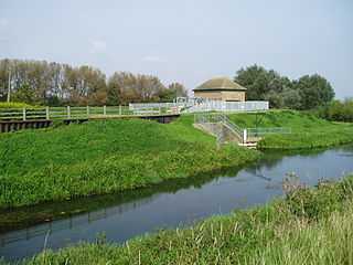
The pumping station (built 1966) at the confluence of the River Glen and the Bourne Eau.
-

Track near Tongue End.
-

Bridge over the Counter Drain
See also
References
- ↑ 1.0 1.1 "The villages around Bourne, Lincolnshire, England - Tongue End", Homepages.which.net. Retrieved 12 October 2008
- ↑ "Lost Pubs In Tongue End, Lincolnshire", Closedpubs.co.uk
- ↑ "We think the confusion over just where the Stamford Canal starts and finishes can be overcome by our choosing our nomemclature more carefully", East Anglian Waterways Association
- ↑ "The Welland & Deeping IDB"
External links
![]() Media related to Tongue End at Wikimedia Commons
Media related to Tongue End at Wikimedia Commons
| |||||||||||||||||
| ||||||||
| ||||||||