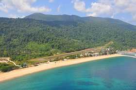
Tioman Airport
From Wikipedia, the free encyclopedia
| Tioman Airport Lapangan Terbang Tioman | |||
|---|---|---|---|
 | |||
| The runway is only accessible from the north, due to the nearby hills at the south end | |||
| IATA: TOD – ICAO: WMBT | |||
| Summary | |||
| Airport type | Public | ||
| Owner | Government of Malaysia | ||
| Operator | Malaysia Airports Berhad | ||
| Serves | Tioman, Pahang, Malaysia | ||
| Location | Tioman Island, Pahang, West Malaysia | ||
| Hub for | Berjaya Air | ||
| Time zone | MST (UTC+08:00) | ||
| Elevation AMSL | 13 ft / 4 m | ||
| Coordinates | 02°49′09″N 104°09′36″E / 2.81917°N 104.16000°ECoordinates: 02°49′09″N 104°09′36″E / 2.81917°N 104.16000°E | ||
| Map | |||
 WMBT | |||
| Runways | |||
| Direction | Length | Surface | |
| m | ft | ||
| 02/20 | 992 | 3,255 | Tarmac |
| Statistics (2012) | |||
| Passengers | 60,141 | ||
| Passenger change 11-12 | | ||
| Aircraft movements | 2,205 | ||
| Movements change 11-12 | | ||
| Sources: AIP Malaysia[1] | |||
Tioman Airport (IATA: TOD, ICAO: WMBT), also known as Pulau Tioman Airport, is an airport serving Tioman Island (Pulau Tioman) in Malaysia. It is located next to Tekek village (Kampung Tekek).
Airlines and destinations
| Airlines | Destinations | Terminal |
|---|---|---|
| Berjaya Air | Kuala Lumpur-Subang | Domestic |
| Berjaya Air | Singapore | International |
Traffic and statistics
| |
handled |
% Change |
Movements |
% Change |
|---|---|---|---|---|
| 2003 | 56,900 | 2,633 | ||
| 2004 | 57,957 | 2,447 | ||
| 2005 | 54,054 | 2,146 | ||
| 2006 | 57,559 | 2,256 | ||
| 2007 | 46,260 | 1,989 | ||
| 2008 | 48,767 | 2,141 | ||
| 2009 | 49,057 | 2,180 | ||
| 2010 | 54,056 | 2,167 | ||
| 2011 | 62,010 | 2,222 | ||
| 2012 | 60,141 | 2,205 |
References
- ↑ AIP Malaysia: WMBT - Pulau Tioman at Department of Civil Aviation Malaysia
- ↑ "MAHB Annual Report 2012". MAHB. Retrieved 6 September 2013.
External links
- Short Take-Off and Landing Airports (STOL) at Malaysia Airports Holdings Berhad
- Accident history for TOD at Aviation Safety Network
| |||||||||||||||||||||||||||||||||
This article is issued from Wikipedia. The text is available under the Creative Commons Attribution/Share Alike; additional terms may apply for the media files.