The Rockpile
From Wikipedia, the free encyclopedia
For other uses, see Rockpile (disambiguation).
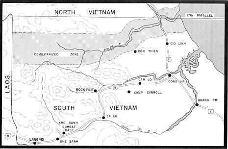
Drawing showing the Rockpile in relation to the DMZ and other northern bases.
The Rockpile (MGRS XD979559), known in Vietnamese as Thon Khe Tri, is a karst rock outcropping near the former South Vietnamese DMZ. It rises to an elevation of 240 metres (790 ft) MSL, about 210 metres (690 ft) above the surrounding terrain. Its relatively inaccessible location, reached only by helicopter, made it an important United States Army and Marine Corps observation post and artillery base from 1966 to 1968.
Gallery
-

Marine UH-34 resupplies the Rockpile
-

The Rockpile today as seen from Route 9
-

Picture from 2009
See also
- History of the United States Marine Corps
- List of United States Marine Corps installations
- Demilitarized Zone
- Khe Sanh
References
- "The Rockpile". Time. October 7, 1966. Retrieved 2008-05-14.
- Photos of the Rockpile on gruntfixer
Coordinates: 16°46′49.82″N 106°51′7.37″E / 16.7805056°N 106.8520472°E
This article is issued from Wikipedia. The text is available under the Creative Commons Attribution/Share Alike; additional terms may apply for the media files.