Thalwil railway station

From Wikipedia, the free encyclopedia
Thalwil
Location
Address Bahnhofstrasse
Municipality Thalwil
Canton Zurich
Country Switzerland
Coordinates 47°17′46″N 8°33′53″E / 47.2960°N 8.5648°E / 47.2960; 8.5648Coordinates: 47°17′46″N 8°33′53″E / 47.2960°N 8.5648°E / 47.2960; 8.5648
Line(s) Lake Zurich left bank line
Elevation 435 m (1,427 ft)
Other information
Owner Swiss Federal Railways
Line ops Swiss Federal Railways
Connections
Services
Preceding station   Swiss rail network   Following station
Zurich Hauptbahnhof   EuroCity
Hamburg to Chur
  Wädenswil
Zurich Hauptbahnhof   EuroCity
Brussels to Chur
  Wädenswil
Zurich Hauptbahnhof   InterRegio
Basel to Chur
  Wädenswil
Zurich Hauptbahnhof   InterRegio
Zurich Airport to Lucerne
  Zug
Zurich Hauptbahnhof   InterRegio
Zurich to Lucerne
  Baar
Zurich Enge   Zurich S-Bahn
S2 service
  Horgen
Rüschlikon   Zurich S-Bahn
S8 service
  Oberrieden
Zurich Enge   Zurich S-Bahn
S21 service
  Oberrieden Dorf
Rüschlikon   Zurich S-Bahn
S24 service
  Oberrieden Dorf

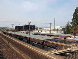
Thalwil is a railway station in the municipality of Thalwil in the Swiss Canton of Zürich. The station is located on the Lake Zurich left bank (Zurich to Chur) main line and Zurich to Lucerne main line railways. To the Zurich side of the station, the Zimmerberg Base Tunnel diverges from the original lakeside line, whilst on the Lucerne side is the junction point where the Zurich to Chur and Zurich to Lucerne lines diverge. Thus all trains on both lines must pass through the station.[1][2]

The station is served on the lakeside line by an hourly long distance service, generally an InterRegio service between Basel and Chur, but sometimes a EuroCity between Hamburg or Brussels and Chur. Further InterRegio services between Zurich and Lucerne operate every half-hour, with one train an hour extended to Zurich Airport. The station is also served by trains on lines S2, S8, S21 and S24 of the Zurich S-Bahn.[3]

Gallery

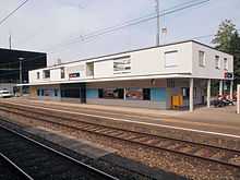
The station building 
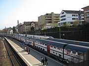
Platforms busy with trains 

References

  1. Swiss Confederation. map.geo.admin.ch (Map). http://map.geo.admin.ch/?selectedNode=node_ch.swisstopo.gg25-gemeinde-flaeche.fill1&Y=685365&X=239015&zoom=7&bgLayer=ch.swisstopo.pixelkarte-farbe&time_current=latest&lang=en. Retrieved 2013-05-10.
  2. Eisenbahnatlas Schweiz. Verlag Schweers + Wall GmbH. 2012. pp. 12–13. ISBN 978-3-89494-130-7. 
  3. "S-Bahn trains, buses and boats". ZVV. Retrieved 2011-09-14. 

External links


This article is issued from Wikipedia. The text is available under the Creative Commons Attribution/Share Alike; additional terms may apply for the media files.