Thalay Sagar
| Thalay Sagar | |
|---|---|
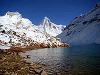
 View of Thalaysagar en route Kedartal | |
| Elevation | 6,904 m (22,651 ft)[1] |
| Prominence | 1,000 m (3,280 ft)[2] |
| Location | |
 Thalay Sagar | |
| Location | Uttarakhand, India |
| Range | Gangotri Group, Garhwal Himalayas |
| Coordinates | 30°51′29″N 78°59′50″E / 30.85806°N 78.99722°ECoordinates: 30°51′29″N 78°59′50″E / 30.85806°N 78.99722°E[1] |
| Climbing | |
| First ascent | June 24, 1979 by Roy Kligfield, John Thackray, Pete Thexton[3] |
| Easiest route | Northwest couloir and ridge: technical rock/snow/ice climb |
Thalay Sagar is a mountain in the Gangotri Group of peaks in the western Garhwal Himalayas, on the main ridge that lies south of the Gangotri Glacier. It lies in the northern Indian state of Uttarakhand, 10 kilometres (6 mi) southwest of the Hindu holy site of Gaumukh (the source of the Bhagirathi River). It is the second highest peak on the south side of the Gangotri Glacier (after Kedarnath), but it is more notable for being a dramatic rock peak, steep on all sides, and a famed prize for mountaineers. It is adjacent to the Jogen group of peaks, and has the lake Kedartal at its base.
Climbing history
The difficulty presented by Thalay Sagar's consistently steep profile prevented any attempts at climbing the peak until the late 1970s, when hard technical rock climbing began to be practiced at high altitude. Unusually for such a hard peak, the first attempt was actually successful. It was first climbed on June 24, 1979 via the northwest couloir and ridge, by an Anglo-American team comprising Roy Kligfield, John Thackray, and Pete Thexton.[3]
Since the first ascent, many other routes have been climbed on the peak, some of which have been testpieces of modern mountaineering. There have been at least 15 ascents[4] by at least 9 different routes. The north face of the peak, in particular, has been climbed by 5 different routes, some more direct than others. The key difficulty in the direct routes is a notorious band of shale near the summit, which presents rotten and dangerous rock. The first route to climb directly through the shale band, instead of finishing on one of the ridges, was the Australian Route followed by Andrew Lindblade and Athol Whimp; it involves 1,400 m (4,600 ft) of climbing and is graded VII 5.9 WI5.[5] Their climb was awarded the Piolet d'Or in 1999.[6]
Just a few years back in 2008 the first successful Indian ascent was accomplished by Basanta Singha Roy the famous climber from Mountaineers Association Of Krishnanagar(MAK),West Bengal, India, along with three sherpas (Pemba sherpa,pasangh sherpa & Phurba sherpa).[7]
On July 22, 2012 Tusi Das,a 28 year old woman climber from Kolkata summited the peak. She was the sole climber in the five-member women’s team from the Alipore-based Kolkata Albatross Adventure Society to reach the summit. It was the first woman ascent to Mt Thalay Sagar recorded so far.[8]
References
- ↑ 1.0 1.1 H. Adams Carter, "Classification of the Himalaya", American Alpine Journal, 1985, p. 140.
- ↑ Corrected version of SRTM data, available at Viewfinder Panoramas
- ↑ 3.0 3.1 Andy Fanshawe and Stephen Venables, Himalaya Alpine-Style, Hodder and Stoughton, 1995, ISBN 0-340-64931-3, pp. 108-111.
- ↑ Himalayan Index
- ↑ Lindblade, Andrew (1998). "To Thalay with Love". American Alpine Journal: pg. 69–77. Retrieved 19 October 2013.
- ↑ "Historique des PO". Retrieved 19 October 2013.
- ↑ http://www.mak.org.in
- ↑ http://www.telegraphindia.com/1120904/jsp/calcutta/story_15900686.jsp#.URkroB1azYo