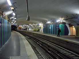
Ternes (Paris Métro)
| Ternes | |||||||||||
|---|---|---|---|---|---|---|---|---|---|---|---|
 | |||||||||||
| Date opened | 7 October 1902 | ||||||||||
| Accesses |
Pl. des Ternes 3, pl. des Ternes 130, boul. de Courcelles | ||||||||||
| Municipality/ Arrondissement | the 8th arrondissement of Paris | ||||||||||
| Fare zone | 1 | ||||||||||
| Next stations | |||||||||||
| |||||||||||
| List of stations of the Paris Métro | |||||||||||

Location of metro station | |||||||||||
Ternes is a station on Paris Métro Line 2, under the Place des Ternes on the border of the 8th and 17th arrondissement of Paris.
The station was opened on 7 October 1902 as part of the extension of line 2 from Étoile to Anvers. The name of the street derives from Villa Externa (Latin for "external house"), a medieval farm and residence of the Bishop of Paris outside the city, that became the name of the locality, which was originally part of Saint-Denis, then Neuilly, and was finally annexed by Paris in 1860. The Barrière des Ternes was a gate (also known as the Barrière du Roule) at the same location built for the collection of taxation as part of the Wall of the Farmers-General; the gate was built between 1784 and 1788 and demolished in 1859.[1][2]
Station layout
| G Street Level |
| B1 | Mezzanine for platform connection |
| P Platform level |
||
| Platform 1 | ← | |
| Platform 2 | → | |
References
- ↑ "Barrière du Roule, picture" (in French). Bibliothèque nationale de France. Retrieved 14 October 2009.
- ↑ "Barrière du Roule" (in French). Bibliothèque nationale de France. Retrieved 14 October 2009.

| Wikimedia Commons has media related to Ternes (Paris Metro). |
| Paris Métro | Line 2 | |
|---|---|---|
| ||
Coordinates: 48°52′40″N 2°17′55″E / 48.87778°N 2.29861°E