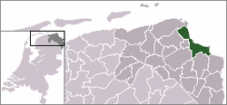
Termunten
From Wikipedia, the free encyclopedia
| Termunten | ||
|---|---|---|
| Village | ||
| ||
 | ||
 | ||
| Coordinates: 53°18′N 7°3′E / 53.300°N 7.050°ECoordinates: 53°18′N 7°3′E / 53.300°N 7.050°E | ||
| Country | Netherlands | |
| Province | Groningen (province) | |
| Municipality | Delfzijl | |
| Area | ||
| • Total | 0.58 km2 (0.22 sq mi) | |
| Population (2008) | ||
| • Total | 420 | |
| • Density | 720/km2 (1,900/sq mi) | |
| Time zone | CET (UTC+1) | |
| • Summer (DST) | CEST (UTC+2) | |
Termunten is a village in the Dutch province of Groningen. It is a part of the municipality of Delfzijl, and lies about 33 km east of Groningen.
Termunten was a separate municipality until 1990, when it was merged with Delfzijl.[1]

Remnant of an antiaircraft gun position built by the Germans in the Second World War along the coast at Termunten.
In 2001, the village of Termunten had 201 inhabitants. The built-up area of the village was 0.082 km², and contained 89 residences.[2] The statistical area "Termunten", which also can include the peripheral parts of the village, as well as the surrounding countryside, has a population of around 620.[3]

Map of Termunten from around 1868
References
- ↑ Ad van der Meer and Onno Boonstra, Repertorium van Nederlandse gemeenten, KNAW, 2006.
- ↑ Statistics Netherlands (CBS), Bevolkingskernen in Nederland 2001. (Statistics are for the continuous built-up area).
- ↑ Statistics Netherlands (CBS), Statline: Kerncijfers wijken en buurten 2003-2005. As of 1 January 2005.
External links
![]() Media related to Termunten at Wikimedia Commons
Media related to Termunten at Wikimedia Commons
- J. Kuyper, Gemeente Atlas van Nederland, 1865-1870, "Termunten". Map of the former municipality, around 1868.
| |||||||||||
| |||||||||||
This article is issued from Wikipedia. The text is available under the Creative Commons Attribution/Share Alike; additional terms may apply for the media files.

