Tepuka

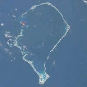
Tepuka is an island eighteen kilometers west of Fongafale, in the northwest of Funafuti,[1][2] the main atoll of the Oceanian nation of Tuvalu. Te puka, or Pouka, is the name of a tree - Hernandia peltata.[3]
There is a well-preserved underground bunker on the island, which was an American communications outpost built during the Pacific War, which was connected to the military airfield on Fongafale.[4] [5]
The island lies between the smaller islet of Tepuka Vili Vili in the southwest, the smaller islet of Te Afualiku in the northeast, the Pacific Ocean on the west and the Funafuti lagoon called Te Namo on the east. In recent years the island has suffered from major erosion. Te Ava Tepuka and Te Avua Sari are two neighbouring passages through Funafuti atoll in the northeast, between the islets of Te Afualiku to the northeast and Tepuka to the southwest.[6]
Tepuka is to the north of the Funafuti Conservation Area, which encompasses 33 square kilometers (12.74 square miles) of reef, lagoon and six motu (islets) to the south of Tepuku: Tepuka Vili Vili, (also called Tepuka Savilivili); Fualopa; Fuafatu; Vasafua; Fuagea (also called Fuakea) and Tefala.
| |||||||||||||||||||||||||
Coordinates: 8°27′46″S 179°04′49″E / 8.4627°S 179.0802°E
References
- ↑ Map of Funafuti. Tuvaluislands.com.
- ↑ Lal, Andrick. South Pacific Sea Level & Climate Monitoring Project - Funafuti atoll. SPC Applied Geoscience and Technology Division (SOPAC Division of SPC). p. 57.
- ↑ Hedley, Charles (1896). General account of the Atoll of Funafuti. Australian Museum Memoir 3(2): 1–72. pp. 17, 31–32.
- ↑ Melei Telavi, Hugh Laracy (ed.) (1983). "Chapter 18 - War". Tuvalu: A History. Institute of Pacific Studies, University of the South Pacific and Government of Tuvalu. p. 142.
- ↑ "Funafuti". Tuvaluislands.com. Retrieved 20 April 2013.
- ↑ Admiralty Nautical Chart 2983 Tuvalu - Funafuti atoll. United Kingdom Hydrographic Office (UKHO).
