Tatoosh Wilderness
| Tatoosh Wilderness | |
|---|---|
|
IUCN category Ib (wilderness area) | |
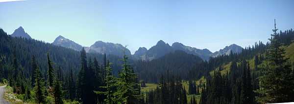
 The Tatoosh Range, taken near Paradise, in Mount Rainier National Park, Washington, United States; panorama of three shots | |
 | |
| Location | Lewis County, Washington, USA |
| Nearest city | Seattle, WA |
| Coordinates | 46°42′0″N 121°39′0″W / 46.70000°N 121.65000°WCoordinates: 46°42′0″N 121°39′0″W / 46.70000°N 121.65000°W |
| Area | 15750 acres (64 km2) |
| Established | 1984 |
| Governing body | United States Forest Service |
The Tatoosh Wilderness, located in Washington, in the Pacific Northwest region of the United States, is managed by the U.S. Forest Service and protects 15,750 acres (64 km2).[1] In 1984 it was officially designated as wilderness by Congress.[2] The Tatoosh Wilderness, a part of Gifford Pinchot National Forest, is a scenic alpine environment that complements the adjacent Mount Rainier National Park. It features Tatoosh Peak, a member of the Tatoosh Range. Its addition to the wilderness system will protect and preserve its natural beauty.
History
Tatoosh means "breast" in the Chinook Jargon,[2] in reference to the two large rock outcrops on the south face of Butter Peak. In 1932, a fire lookout was built. Martha Hardy later wrote about her experiences keeping watch at the fire lookout in her 1947 book Tatoosh (ISBN 0-89886-005-9).
The Tatoosh Wilderness is accessible from the north from Mt. Rainier National Park and from the south via the Tatoosh Lakes trail. A spur of the Tatoosh Lakes trail extends to the location of the fire lookout that Martha Hardy wrote about, although only the foundations of the lookout building remain.
References
- ↑ "Tatoosh Wilderness". Recreation.gov. 2006-11-16. Retrieved 2010-10-12.
- ↑ 2.0 2.1 "Tatoosh Wilderness". Gifford Pinchot National Forest, USDA Forest Service. 2005-03-28. Retrieved 2006-11-25.