Tarnów Opolski
| Tarnów Opolski | ||
|---|---|---|
| Village | ||
 | ||
| ||
 Tarnów Opolski | ||
| Coordinates: 50°35′N 18°5′E / 50.583°N 18.083°E | ||
| Country |
| |
| Voivodeship | Opole Voivodeship | |
| County | Opole County | |
| Gmina | Tarnów Opolski | |
| Population | 3,800 | |
| Website | http://www.tarnowopolski.pl | |
Tarnów Opolski [ˈtarnuf ɔˈpɔlski] is a village in Opole County, Opole Voivodeship, in south-western Poland. It is the seat of the gmina (administrative district) called Gmina Tarnów Opolski.[1] It lies approximately 15 km (9 mi) south-east of the regional capital Opole.
Before 1945 the area was part of Germany (see Territorial changes of Poland after World War II).
The village has a population of 3,800.
Name
Tarnow name probably comes from the Old Polish name of the bush "Blackthorn", or tarni define a place where this plant grows. Originally called Tarnów great to distinguish it from the nearby town of Tarnowiec. Polish Tarnow and Germanized name Tarnau lists in 1896 Silesian writer Constantine Damrot in a book about the naming of the local in Silesia. Damrot in his book also mentions older Tarnov name taken from the Latin documents from the years 1335 and 1369. Geographical Dictionary of the Polish Kingdom released at the end of the nineteenth century, given the Polish name of Tarnów Polish and German Englisch Tarnau. Today the name is Tarnów Opolski to distinguish it from other places in Poland with that name.
Heritage
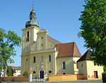
According to the Register of the National Institute of Heritage sites inscribed on the list is:[2] Church pairs. pw. St. Martin, whose origins date back to the period of the first half. The fifteenth century, in the years 1653 to 1664 - the seventeenth century the nave and the tower, further stages of the construction of the church fall on years 1853 to 1864, 1913, church has a baroque altar with statues of saints Michael, Joseph and Hedwig, rococo font from the second half of the eighteenth century. The church is the ossuary of the eighteenth and nineteenth centuries.
References
- ↑ "Central Statistical Office (GUS) - TERYT (National Register of Territorial Land Apportionment Journal)" (in Polish). 2008-06-01.
- ↑ "List of heritage registers" (in Polish). 2013-08-20.
External links
| ||||||||
Coordinates: 50°35′N 18°5′E / 50.583°N 18.083°E
