Tampaksiring
From Wikipedia, the free encyclopedia
| Tampaksiring | |
|---|---|
 | |
 Tampaksiring | |
 Tampaksiring | |
| Coordinates: 8°25′S 115°18′E / 8.417°S 115.300°E | |
| Country | Indonesia |
| Province | Bali |
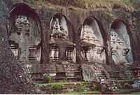
Tampaksiring is a town in central Bali, Indonesia. It is the home to the Gunung Kawi Temple [1] and the Senang Hati Foundation.
In the past, Tampaksiring was one of the governance centers in Bali during the kingdom period.
Tampaksiring is the site of the Tampaksiring Presidential Palace. The Palace was built between 1957-1960 at the initiation of President Soekarno. [2]
Villages in Tampaksiring are: Manukaya, Pejeng, Pejeng Kaja, Pejeng Kangin, Pejeng Kawan, Pejeng Kelod, Sanding, and Tampaksiring.
References
- ↑ wonderfulbali.com. "Tampaksiring, Valley of the Kings - Gunung Kawi". Retrieved 2007-12-20.
- ↑ Government of The Republic of Indonesia. "Republic of Indonesia - Tampaksiring Presidential Palace". Retrieved 2007-12-20.
External links
![]() Central Bali travel guide from Wikivoyage
Central Bali travel guide from Wikivoyage
Coordinates: 8°25′S 115°18′E / 8.417°S 115.300°E
This article is issued from Wikipedia. The text is available under the Creative Commons Attribution/Share Alike; additional terms may apply for the media files.