Taliabu
From Wikipedia, the free encyclopedia
 | |
| Geography | |
|---|---|
| Location | South East Asia |
| Coordinates | 1°48′S 124°48′E / 1.8°S 124.8°ECoordinates: 1°48′S 124°48′E / 1.8°S 124.8°E |
| Archipelago | Maluku Islands |
| Area | 2,913 km2 (1,125 sq mi) |
| Country | |
|
Indonesia | |
| Demographics | |
| Population | 47,309 (as of 2010 Census) |
| Density | 16 /km2 (41 /sq mi) |
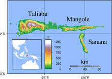
Taliabu is a large island (2,913 km²) and a Regency in the Sula Islands, which again are part of the Maluku Islands in Indonesia. It is located at 1°48′S 124°48′E / 1.8°S 124.8°E, west of Mangole Island and Sanana Island.
Administration
In 2013 the 7 districts (kecamatan) on Taliabu Islands were split off from the Sula Islands Regency to create a separate Taliabu Island Regency (Pulau Taliabu); they are tabulated below with their 2010 Census population.
| Name | English name | Population Census 2010 |
|---|---|---|
| Lede | 5,977 | |
| Taliabu Barat | West Taliabu | 9,027 |
| Taliabu Barat Laut | Northwest Taliabu | 4,079 |
| Taliabu Selatan | South Taliabu | 8,738 |
| Taliabu Timur | East Taliabu | 3,542 |
| Taliabu Timur Selatan | Southwest Taliabu | 5,066 |
| Taliabu Utara | North Taliabu | 10,880 |
| Taliabu Island Regency | 47,309 |
This article is issued from Wikipedia. The text is available under the Creative Commons Attribution/Share Alike; additional terms may apply for the media files.