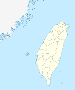
Taitung City
| Taitung 臺東 | |
|---|---|
| County-controlled city | |
臺東市 · Taitung City | |
 | |
| Nickname(s): 東市 (Eastern City) | |
 Taitung | |
| Coordinates: 22°45′30″N 121°08′40″E / 22.75833°N 121.14444°ECoordinates: 22°45′30″N 121°08′40″E / 22.75833°N 121.14444°E | |
| Country |
|
| County | Taitung |
| Government | |
| • Mayor | Cheng Jiange (陳建閣) |
| Area | |
| • Total | 109.7691 km2 (42.3821 sq mi) |
| Population (January 2009) | |
| • Total | 109,584 |
| • Density | 1,000/km2 (2,600/sq mi) |
| Website | www.taitungcity.gov.tw |
| Taitung City | |||||||||||||||||||||
| Simplified Chinese | 台东市 | ||||||||||||||||||||
|---|---|---|---|---|---|---|---|---|---|---|---|---|---|---|---|---|---|---|---|---|---|
| Traditional Chinese | 台東市 or 臺東市 | ||||||||||||||||||||
| Literal meaning | Eastern Taiwan | ||||||||||||||||||||
| |||||||||||||||||||||

Taitung, officially known as Taitung City (Chinese: 台東市 or 臺東市; pinyin: Táidōng Shì), is the county seat of Taitung County, Taiwan. It lies on the southeast coast of Taiwan facing the Pacific Ocean. Taitung City is the most populous subdivision of Taitung County and it is one of the major cities on the east coast of the island.
Due to the Central Mountain Range of Taiwan, ground transportation to Taitung City is very limited. The city is served by Taitung Airport. Taitung is a gateway to Green Island and Orchid Island, both of which are popular tourist destinations.
History
Before the 16th century the Taitung plain was settled by agriculturalist Puyuma and Amis tribes. Under the Dutch and during the Qing Dynasty, a large part of east Taiwan, including today's Taitung Prefecture, was called Beinan.
In the late 19th century, when Liu Mingchuan was the Qing Governor of Taiwan, Han Chinese settlers moved into the Taitung region and established a settlement, Taitung State. In the time Taiwan was under Japanese rule the central settlement was called Nankyou Village. After World War II it became Taitung Town and in 1976 it was promoted to Taitung City.
Climate
Taitung has a tropical monsoon climate, with a wet season from May to October, a dry season from November to April, and consistently very warm to hot temperatures with high humidity. Unlike most tropical climates, however, the dry season is foggy rather than sunny, so that moisture availability during this period is greater than the low rainfall and warm temperatures would suggest.
| Climate data for Taitung City (1981−2010) | |||||||||||||
|---|---|---|---|---|---|---|---|---|---|---|---|---|---|
| Month | Jan | Feb | Mar | Apr | May | Jun | Jul | Aug | Sep | Oct | Nov | Dec | Year |
| Average high °C (°F) | 23.1 (73.6) |
23.6 (74.5) |
25.4 (77.7) |
27.7 (81.9) |
29.8 (85.6) |
31.4 (88.5) |
32.3 (90.1) |
32.2 (90) |
31.0 (87.8) |
29.3 (84.7) |
26.9 (80.4) |
24.1 (75.4) |
28.07 (82.52) |
| Daily mean °C (°F) | 19.5 (67.1) |
20.0 (68) |
21.8 (71.2) |
24.1 (75.4) |
26.2 (79.2) |
27.8 (82) |
28.9 (84) |
28.7 (83.7) |
27.5 (81.5) |
25.7 (78.3) |
23.3 (73.9) |
20.5 (68.9) |
24.5 (76.1) |
| Average low °C (°F) | 16.8 (62.2) |
17.4 (63.3) |
19.0 (66.2) |
21.2 (70.2) |
23.4 (74.1) |
25.1 (77.2) |
26.0 (78.8) |
25.9 (78.6) |
24.8 (76.6) |
23.1 (73.6) |
20.8 (69.4) |
17.9 (64.2) |
21.78 (71.2) |
| Rainfall mm (inches) | 30.5 (1.201) |
40.2 (1.583) |
40.5 (1.594) |
65.6 (2.583) |
155.9 (6.138) |
227.8 (8.969) |
270.5 (10.65) |
302.0 (11.89) |
344.6 (13.567) |
182.3 (7.177) |
79.2 (3.118) |
40.5 (1.594) |
1,779.6 (70.064) |
| Avg. rainy days (≥ 0.1 mm) | 8.7 | 9.6 | 9.0 | 11.1 | 14.1 | 12.5 | 10.0 | 11.0 | 13.7 | 9.9 | 7.8 | 7.5 | 124.9 |
| % humidity | 71.4 | 73.1 | 73.7 | 75.2 | 76.7 | 77.7 | 75.8 | 76.0 | 76.5 | 72.5 | 70.8 | 69.3 | 74.1 |
| Mean monthly sunshine hours | 95.8 | 83.6 | 104.2 | 115.0 | 143.4 | 188.7 | 245.1 | 219.4 | 160.6 | 150.4 | 119.1 | 102.5 | 1,727.8 |
| Source: Central Weather Bureau[1] | |||||||||||||
Education
Transportation

- TRA:Hwa-tung Line, South-Link Line
- Taitung Station
- Kangle Station
- Zhiben Station
- Taiwan Provincial Highway System
- Provincial Highway No. 9
- Provincial Highway No. 11
- Port
- Fukang Port - ferry port to Orchid Island (Lanyu) and Green Island
- Airport
Tourist attractions
- Beinan Cultural Park
- Fugang Fish Harbor
- Jialulan Recreation Area
- Liyu Mountain Park
- National Museum of Prehistory
- Paposogan
- Taitung Art Museum
- Taitung Forest Park
- Taitung Railway Art Village[2]
- Taitung Story Museum
- Tiehua Music Village
- Xiao Yehliu
See also
References
External links
| Wikimedia Commons has media related to Taitung City. |
| |||||||||||||||||

