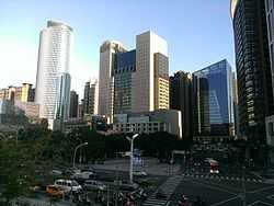
Taipei–Keelung metropolitan area
| Taipei–Keelung Metropolitan Area / Greater Taipei | |
|---|---|
 | |
| Coordinates: 25°2′N 121°38′E / 25.033°N 121.633°ECoordinates: 25°2′N 121°38′E / 25.033°N 121.633°E | |
| Country |
|
| Major Cities |
Taipei New Taipei Keelung |
| Area | |
| • Metro | 2,457.13 km2 (874.59 sq mi) |
| Population (End of January 2012) | |
| • Metro | 6,950,646 |
| • Metro density | 2,800/km2 (7,900/sq mi) |
The Taipei–Keelung metropolitan area (Chinese: 臺北基隆都會區; pinyin: Táiběi-Jīlóng Dūhùiqū) or Greater Taipei area / region (大臺北地區) is the largest metropolitan area in Taiwan. The metropolitan area includes Taipei City, New Taipei City, and Keelung City. However, the Taiwanese government has officially abolished its prior official definition of the metropolitan area due to the transformation of Taipei County into New Taipei.[1]
Definition
The most common definition of the Taipei–Keelung metropolitan area is to include the two core cities of Taipei and Keelung along with the districts which make up New Taipei.
| Division name | Population (31 December 2012)[2] | Area (km²) | Density (per km²) |
|---|---|---|---|
| Taipei City | 2,650,968 | 271.80 | 9,753.3 |
| New Taipei City | 3,916,451 | 2,052.57 | 1,908.1 |
| Keelung City | 377,153 | 132.76 | 2,840.9 |
| Taipei–Keelung metropolitan area | 6,944,572 | 2,457.13 | 2,826.3 |
| Taoyuan County | 2,030,161 | 1,220.95 | 1,662.3 |
| Taipei–Keelung–Taoyuan metropolitan area | 8,974,733 | 3,678.08 | 2,440.1 |
Some international reports consider Taipei–Keelung–Taoyuan (Chinese: 臺北基隆桃園都會區; pinyin: Táiběi–Jīlóng–Táoyuán Dūhùiqū) as a real complete metropolitan area.[2][3][4]
Geography
Due to the geographical characteristics of the area, the Taipei–Keelung metropolitan area roughly corresponds to areas located within the Taipei Basin. Taipei City serves as the core of the metropolitan area where the government of the Taiwan and major commercial districts are located.
Geographical Subdivision
The metropolitan area contains Taipei City, Keelung City and most part of New Taipei City (except Pinglin District and Yingge District). The geographical subdivision listed as followed.

|
| |
| ||
Transportation
Rail

The Taipei–Keelung metropolitan area is served by routes of the Taiwan Railway Administration (Western Line) and Taiwan High Speed Rail which connect the area with all parts of the island. For rapid transit, Taipei and New Taipei are served by the Taipei Metro with daily trips of over 1.5 million passengers.
Air
The area is served by Taiwan Taoyuan International Airport for international flights and Songshan Airport for domestic and cross-strait flights.
Bus
An extensive bus system serves the metropolitan area.
See also
- Administrative divisions of the Republic of China
- Geography of Taiwan
- List of metropolitan areas in Asia by population
- List of Taiwanese counties and cities by area
- List of Taiwanese counties and cities by population
- List of Taiwanese counties and cities by population density
- Political divisions of Taiwan (1895-1945)
References
- ↑ "「中華民國統計地區標準分類」自99年12月25日起停止適用". Retrieved 2010-07-04.
- ↑ 2.0 2.1 "鄉鎮市區人口及按都會區統計". Taiwan Ministry of Interior. 2013. Retrieved December 2013.
- ↑ World: metropolitan areas World Gazetteer, 2010
- ↑ Taipei: largest cities and towns and statistics of their population World Gazetteer, 2010