Taipa-Mangonui
| Taipa-Mangonui | |
|---|---|
 Taipa-Mangonui | |
| Coordinates: 34°59′44″S 173°27′53″E / 34.99556°S 173.46472°E | |
| Country | New Zealand |
| Region | Northland Region |
| District | Far North District |
| Population (2006) | |
| • Total | 1,566 |
Taipa-Mangonui is one name given to a string of small resort settlements in the far north of New Zealand's North Auckland Peninsula, close to the base of the Aupouri Peninsula. The resorts of Taipa, Cable Bay, Coopers Beach, and Mangonui, all of which lie along the coast of Doubtless Bay, are so close together that they have run together to form one larger settlement with a combined population of 1566 (2006 census).[1]
The "miniature conurbation" lies 150 kilometres by road northwest of Whangarei (though only 100 kilometres as the crow flies), and 20 kilometres northeast of Kaitaia. It is thus the northernmost centre in New Zealand with a population of above 1000, even though it is nearly 100 kilometres southeast of the northernmost tip of the North Island. Mangonui means "big shark" in the Maori language.[2] In the 19th century, the spelling of Mongonui was more common,[3] and the Mongonui electorate filled one seat in Parliament between 1861 and 1881.[4]
Education
Taipa Area School is a composite (years 1-15) school with a roll of 464.[5] The school claims to be the only one in New Zealand to have a team of students who are qualified surf lifeguards patrolling beach activities during terms 1 and 4.[6]
Mangonui School is a contributing primary (years 1-6) school with a roll of 151.[7] The school opened in 1857, and one of the original buildings is still in use as the school library.[8]
Both schools are coeducational and have a decile rating of 3. Coordinates: 34°59′44″S 173°27′53″E / 34.99556°S 173.46472°E
Gallery
-

Rangikapiti Pa as seen from George Street Mangonui
-

Rangikapiti Pa and Inlet to the Mangonui harbour
-
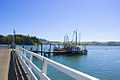
The harbour at Mangonui
-

Dense housing around Mangonui
-

Coopers Beach from Rangikapiti
-

Coopers Beach
Notes
- ↑ Quickstats about Taipa Bay-Mangonui
- ↑ "This Is The Place - Story Details The Naming of Mangonui". thisistheplace.org.nz. Retrieved 2010-07-19.
- ↑ Cyclopedia Company Limited (1902). "Mongonui". The Cyclopedia of New Zealand : Auckland Provincial District. Christchurch: The Cyclopedia of New Zealand. Retrieved 11 February 2013.
- ↑ Wilson, James Oakley (1985) [First ed. published 1913]. New Zealand parliamentary record, 1840–1984 (4 ed.). Wellington: V.R. Ward, Govt. Printer. p. 267. OCLC 154283103.
- ↑ "Te Kete Ipurangi - Taipa Area School". Ministry of Education.
- ↑ "Welcome to Taipa Area School".
- ↑ "Te Kete Ipurangi - Mangonui School". Ministry of Education.
- ↑ "All About Mangonui School".
External links
|