Tōsenkyō
Tōsenkyō (唐船峡) is a gorge located in Ibusuki, Kagoshima Prefecture in southern Japan. It stands southwest of the Ikeda Lake. Tōsenkyō derives from place name of Tōsen-ga-saka, which had a deep cove in the Edo Period (1603–1868), so many Chinese ship came to an anchor there (tōsen means Chinese ships[1]).
Tōsenkyō and sōmen


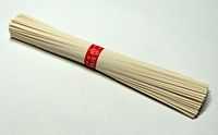
The reason why Tōsenkyō is famous for all over the country, is the nagashi-sōmen or sōmen-nagashi (“flowing noodles”),[2] which is regarded as summer attraction (outdoor party cuisine).
Ordinarily way of flowing noodles is that the noodles are placed in a long flume of bamboo across the length of the restaurant. The flume carries clear, ice-cold water. As the sōmen pass by, diners pluck them out with their chopsticks and dip them in tsuyu (sauce, juice, sap, soup, broth[3]).
In 1962, people sought a way to use the clear stream in Tōsenkyō, for their first trial they poured thin noodles through bamboo as normal. It got much attention. Based on this plan, Inoue Hironori invented a turn-style motorized machine which is able to swirl thin noodles around inside it. Originally, this machine was under a personal patent, but in 1967 he transferred the patent to Ibusuki city. The city then put this machine to practical use as part of its efforts to develop the town, and publicized Tōsenkyō as the birthplace of flowing noodles.
Today, Tōsenkyō is called village of nagashi-sōmen. The park is maintained, and tourists can go there easily. Miso soup with carp in it is also famous there. Wasabi is grown commercially in the clear stream across Tōsenkyō. Sturgeons have also been farmed in recent years in a study to make caviar a special product.
See also
- Chanpurū
- Somen salad
References
- ↑ Kenkyusha's New Japanese-English Dictionary, Kenkyusha Limited, ISBN 4-7674-2015-6
- ↑ http://toyohara.com/inaka/somen-e.htm
- ↑ Kenkyusha's New Japanese-English Dictionary, Kenkyusha Limited, ISBN 4-7674-2015-6
References
Coordinates: 31°13′13″N 130°32′34″E / 31.22028°N 130.54278°E