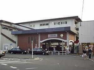
Tōbu-Dōbutsu-Kōen Station
From Wikipedia, the free encyclopedia
Not to be confused with Tama-Dōbutsukōen Station.
Tōbu-Dōbutsu-Kōen Station 東武動物公園駅 | |
 | |
|---|---|
| East entrance | |
| Location | |
| Prefecture | Saitama (See other stations in Saitama) |
| District | Minami-Saitama |
| Town | Miyashiro |
| Neighborhood etc. | 2-3-24 Monma |
| Postal code | 345-0801 |
| (in Japanese) | 南埼玉郡宮代町百間2-3-24 |
| History | |
| Year opened | 1899 |
| Former name | Sugito Station |
| Present name since | 1981 |
| Rail services | |
| Operator(s) | Tobu Railway |
| Line(s) | Tobu Skytree Line Tōbu Nikkō Line Tobu Isesaki Line |
| Statistics | 33,110 passengers/day (FY2007)[1] |
Tōbu-Dōbutsu-Kōen Station (東武動物公園駅 Tōbu-Dōbutsu-Kōen-eki) is a railway station in Miyashiro, Saitama, Japan, operated by the private railway operator Tobu Railway.
Lines
The station is served by the Tobu Skytree Line, and forms the starting point of Tobu Isesaki Line and Tōbu Nikkō Line. It is 41.0 km from the line's Tokyo terminus at Asakusa.[2]
Station layout
The station has two island platforms serving four tracks.
Platforms

Station platforms
| 2 | ■Tobu Skytree Line | for Kasukabe, Kita-Senju, and Asakusa |
| 3 | ■Tobu Skytree Line | for Kasukabe, Kita-Senju and Asakusa |
| 4 | ■Tōbu Nikkō Line | for Satte, Minami-Kurihashi, Kurihashi, Tochigi, Shin-Tochigi, and Tōbu Nikkō |
| 5 | ■Tobu Isesaki Line | for Kuki, Tatebayashi, Ōta, and Isesaki |
Adjacent stations
| « | Service | » | ||
|---|---|---|---|---|
| Tobu Skytree Line (TS-30) | ||||
| Limited Express Spacia: no stop | ||||
| Kita-Senju (TS-09) | Limited Express Ryōmō | Through to Tobu Isesaki Line | ||
| Kasukabe (TS-27) | Limited Express Shimotsuke | Through to Tobu Nikko Line | ||
| Kasukabe (TS-27) | Limited Express Kirifuri | Through to Tobu Nikko Line | ||
| Kasukabe (TS-27) | Rapid | Through to Tobu Nikko Line | ||
| Kasukabe (TS-27) | Section Rapid | Through to Tobu Nikko Line | ||
| Kasukabe (TS-27) | Express | Through to Tobu Nikko/Isesaki Line | ||
| Kasukabe (TS-27) | Section Express | Through to Tobu Nikko/Isesaki Line | ||
| Himemiya (TS-29) | Semi-Express | Through to Tobu Nikko/Isesaki Line | ||
| Himemiya (TS-29) | Section Semi-Express | Through to Tobu Nikko/Isesaki Line | ||
| Himemiya (TS-29) | Local | Through to Tobu Nikko/Isesaki Line | ||
| Himemiya (TS-29) | Local (Hibiya Line through services) | Through to Tobu Nikko Line | ||
| Tobu Isesaki Line (TS-30) | ||||
| Through to Tobu Skytree Line | Limited Express Ryōmō | Kuki (TI-02) | ||
| Through to Tobu Skytree Line | Express | Wado (TI-01) | ||
| Through to Tobu Skytree Line | Section Express | Wado (TI-01) | ||
| Through to Tobu Skytree Line | Semi-Express | Wado (TI-01) | ||
| Through to Tobu Skytree Line | Section Semi-Express | Wado (TI-01) | ||
| Through to Tobu Skytree Line | Local | Wado (TI-01) | ||
| Tobu Nikko Line (TS-30) | ||||
| Limited Express Spacia: no stop | ||||
| Through to Tobu Skytree Line | Limited Express Shimotsuke | Tochigi (TN-11) | ||
| Through to Tobu Skytree Line | Limited Express Kirifuri | Sugito-Takanodai (TN-01) | ||
| Through to Tobu Skytree Line | Rapid | Itakura Tōyōdai-mae (TN-07) | ||
| Through to Tobu Skytree Line | Section Rapid | Itakura Tōyōdai-mae (TN-07) | ||
| Through to Tobu Skytree Line | Express | Sugito-Takanodai (TN-01) | ||
| Through to Tobu Skytree Line | Section Express | Sugito-Takanodai (TN-01) | ||
| Through to Tobu Skytree Line | Semi-Express | Sugito-Takanodai (TN-01) | ||
| Through to Tobu Skytree Line | Section Semi-Express | Sugito-Takanodai (TN-01) | ||
| Through to Tobu Skytree Line | Local | Sugito-Takanodai (TN-01) | ||
History

Sugito Station in the early 20th century
The station opened on 27 August 1899 as Sugito Station.[2] It was renamed on 16 March 1981[2] after the Tōbu Dōbutsu Kōen (東武動物公園) zoo and amusement park complex run by Tobu, which is a ten-minute walk from the station.
References
External links
| Wikimedia Commons has media related to Tōbu Dōbutsu Kōen Station. |
- Station information (Tobu) (Japanese)
- Station information (Saitama Prefectural Government) (Japanese)
| |||||
| |||||
Coordinates: 36°1′29.5392″N 139°43′36.4152″E / 36.024872000°N 139.726782000°E
This article is issued from Wikipedia. The text is available under the Creative Commons Attribution/Share Alike; additional terms may apply for the media files.