Tévenon
| Tévenon | ||||||||||
|---|---|---|---|---|---|---|---|---|---|---|
| ||||||||||
| Population | 744 (Dec 2012)[1] | |||||||||
| - Density | 43 /km2 (110 /sq mi) | |||||||||
| Area | 17.5 km2 (6.8 sq mi) | |||||||||
| Postal code | ||||||||||
| SFOS number | 5571 | |||||||||
| Surrounded by | Fontaines-sur-Grandson, Mauborget | |||||||||
| Website | Tévenon.ch Profile, SFSO statistics | |||||||||
 Tévenon | ||||||||||
| Location of Tévenon
 | ||||||||||
Tévenon is a municipality in the district of Jura-Nord Vaudois in the canton of Vaud in Switzerland.
The municipalities of Fontanezier, Romairon, Vaugondry and Villars-Burquin merged on 1 July 2011 into the new municipality of Tévenon.[2]
History
Fontanezier is first mentioned in 1403 as Fontanisy.[3] Romairon is first mentioned in 1403 as Romeyron.[4]
Geography
Tévenon has an area, as of 2009, of 17.49 square kilometers (6.75 sq mi). Of this area, 7.51 km2 (2.90 sq mi) or 42.9% is used for agricultural purposes, while 9.15 km2 (3.53 sq mi) or 52.3% is forested. Of the rest of the land, 0.64 km2 (0.25 sq mi) or 3.7% is settled (buildings or roads) and 0.03 km2 (7.4 acres) or 0.2% is unproductive land.[5]
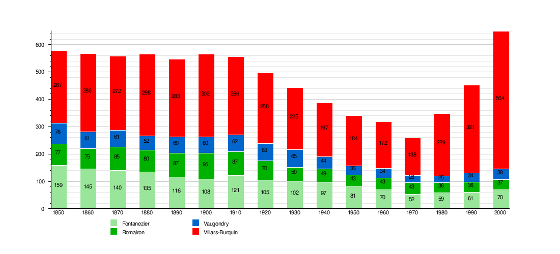
Historic Population
The historical population is given in the following chart:[3][4][6]

Sights
The entire hamlet of Vaugondry is designated as part of the Inventory of Swiss Heritage Sites[7]
References
- ↑ Swiss Federal Statistics Office – STAT-TAB Ständige und Nichtständige Wohnbevölkerung nach Region, Geschlecht, Nationalität und Alter (German) accessed 17 September 2013
- ↑ Amtliches Gemeindeverzeichnis der Schweiz published by the Swiss Federal Statistical Office (German) accessed 17 February 2011
- ↑ 3.0 3.1 Fontanezier in German, French and Italian in the online Historical Dictionary of Switzerland.
- ↑ 4.0 4.1 Romairon in German, French and Italian in the online Historical Dictionary of Switzerland.
- ↑ Swiss Federal Statistical Office-Land Use Statistics 2009 data (German) accessed 25 March 2010
- ↑ Federal Statistical Office STAT-TAB Bevölkerungsentwicklung nach Region, 1850-2000 (German) accessed 29 January 2011
- ↑ "Kantonsliste A-Objekte". KGS Inventar (in German). Federal Office of Civil Protection. 2009. Retrieved 25 April 2011.
| Wikimedia Commons has media related to Tévenon. |
| |||||||
