Tálknafjarðarhreppur
From Wikipedia, the free encyclopedia
| Tálknafjarðarhreppur | |
|---|---|
| Municipality | |
 | |
| Coordinates: 65°37′38″N 23°49′23″W / 65.62722°N 23.82306°W | |
| Country |
|
| Constituency[1] | Norðvesturkjördæmi |
| Region[2] | Vestfirðir |
| County | Strandasýsla |
| Area | |
| • Total | 176 km2 (68 sq mi) |
| Population (January 2011) | |
| • Total | 306 |
| Time zone | GMT (UTC+0) |
| Postcode | 460 |
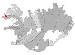
Tálknafjarðarhreppur is a municipality in Iceland.
According to the 2011 census, it had a population of 306 inhabitants. The only settlement is Tálknafjörður. On the land side the municipality is surrounded by the municipality of Vesturbyggð. There is considerable cooperation between the two municipalities but unification was voted down in the latest election.
References
65°37′38″N 23°49′23″W / 65.627159°N 23.823009°W
This article is issued from Wikipedia. The text is available under the Creative Commons Attribution/Share Alike; additional terms may apply for the media files.