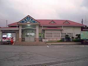
Susono Station
Susono Station 裾野駅 | |
 | |
|---|---|
| Susono Station building | |
| Location | |
| Prefecture | Shizuoka (See other stations in Shizuoka) |
| City | Susono |
| Neighborhood etc. | Hiramatsu |
| Postal code | 410-1127 |
| (in Japanese) | 静岡県裾野市平松 |
| History | |
| Year opened | 1889 |
| Rail services | |
| Operator(s) | JR Central |
| Line(s) | Gotemba Line |
| Statistics | 2,785 passengers/day (FY2006) |
Susono Station (すそのえき Susono-eki) is a railway station on the Gotemba Line in the southern part of Susono, Shizuoka, Japan, operated by Central Japan Railway Company (JR Central).
Lines
Susono Station is served by the Gotemba Line.
Station layout

Susono Station has a single island platform. The station building has automated ticket machines, TOICA automated turnstiles and a "Midori no Madoguchi" ticket office, and is manned only during daytime hours. It is located to the west of tracks and is connected to the platform with an overpass.
Platforms
| 1 | ■Gotemba Line | for Gotemba, Yamakita, Matsuda, and Kōzu |
| 2 | ■Gotemba Line | for Numazu |
Adjacent stations
| « | Service | » | ||
|---|---|---|---|---|
| Gotemba Line | ||||
| Iwanami | Local | Nagaizumi-Nameri | ||
History
The station first opened as Sano Station (佐野駅) under the Japanese Government Railways (JGR), (the predecessor to the post-war Japanese National Railways) on February 1, 1889. It was renamed Susono Station on July 15, 1915. After the opening of the Tanna Tunnel on December 1, 1934, it became a station of the Gotemba Line. Regularly scheduled freight services were discontinued on March 10, 1974 and baggage-handling services from February 1, 1984. Along with its division and privatization of JNR on April 1, 1987, the station came under the control and operation of JR Central.
References
- Harris, Ken and Clarke, Jackie. Jane's World Railways 2008-2009. Jane's Information Group (2008). ISBN 0-7106-2861-7
- Ishino, Tetsu et al. (eds.) (1998). Teishajō Hensen Daijiten - Kokutetsu JR Hen (in Japanese). Tokyo: JTB Corporation. vol. II. ISBN 4533029809.
External links
| Wikimedia Commons has media related to Susono Station. |
- Gotemba Line Users' Association information (Japanese)
Coordinates: 35°10′19.10″N 138°54′33.51″E / 35.1719722°N 138.9093083°E