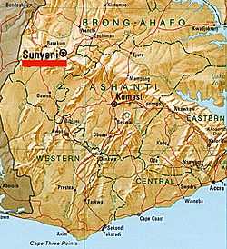
Sunyani
| Sunyani City of Sunyani | ||
|---|---|---|
| City | ||
 | ||
| ||
| Nickname(s): Sun city | ||
 | ||
| Coordinates: 7°20′N 2°20′W / 7.333°N 2.333°W | ||
| Country |
| |
| Region | Brong Ahafo | |
| District | Sunyani Municipal District | |
| Elevation | 303 m (994 ft) | |
| Population (2012) | ||
| • Total | 248,496 | |
| Time zone | GMT | |
| • Summer (DST) | GMT (UTC) | |
| Area code(s) | 035 | |
Sunyani is a city and the capital of Sunyani Municipal and Brong-Ahafo of south Ghana. Sunyani has a population of 248,496 people as of 2012 census.[1][2]
History
Sunyani is surrounded by the forested Southern Ashanti Uplands, the city of Sunyani arose as an outpost camp for elephant hunters during the 19th century. The name Sunyani derives from the Akan word for elephant "Osono".[3] In 1924, The British Empire government designated Sunyani as a district headquarters.[3] Following the construction of a road connecting Sunyani and the city of Kumasi, Sunyani became an important hub for the distribution of cocoa, kola nuts, and staple foods such as maize and yams.[3] Today Sunyani is home to both the Brong-Ahafo regional government and high court. Although considerably smaller than nearby Kumasi, Sunyani is growing rapidly and has effectually engulfed the suburbs of Fiapre and Abesim, amongst others. Sunyani is a clean and well maintained city with a thriving economy.[3]
Education
The Brong-Ahafo region's post-secondary institutions are also based in the city; including the polytechnic school, the College of Renewable National Resources.[4] Several of the country's best primary and secondary and technical schools can be found within Sunyani and its suburbs, including: St. Mary's; Lawrence Demonstration; Wesley's; Divine Montessori; Ridge Primary; Twene Amanfo Secondary Technical School (TASTECH); and Don Bosco Vocational Technical Institute.[4] Attracting students from throughout the Brong-Ahafo region and beyond, is the highly ranked Sunyani Senior High School (Susec) and St. James seminary which has been rated among, the best five Senior High Schools in Ghana.[4]
Economy
The economy of Sunyani is predominantly agrarian with approximately 48% of the population engaged in agriculture production. About 24 percent of the population is employed in the service sector, followed by commerce and industry which employ 15% and 13% of the populace, respectively.[3]
The city’s growth is boosted by Sunyani’s high-quality water supply. Sunyani is provided with electricity by the Volta River Authority (VRA).[3] Water sources include rain water and water from streams, rivers and springs. However, in severe harmattan (dry) conditions, water can become more difficult to access.
Banking
The city has a number of financial institutions including a branch of the BoG, Commercial Bank, Barclays Bank, SG-SSB Bank, Agricultural Development Bank, EcoBank and the National Investment Bank.[3] There are also six rural banks, a number of credit unions and insurance institutions complementing the financial service provision of the city.[3]
Communications
The city of Sunyani is outfitted with modern communication facilities which include fixed telephone and fax lines, pay phones, mobile phones, internet and e-mail services. Additionally; postal services are available in the form of post office, as well as expedited mail services provided by EMS (Express mail service), DHL and FedEx.[3]
Tourism
Tourists are beginning to venture to Sunyani in greater numbers, attracted by the areas of natural beauty surrounding the city.[3] Such visitors take advantage of the city’s three 3-star hotels, over fifteen modern hotels and rated hostels, and a number of guest houses and restaurants that are also found in the city.[3] Among the city’s attractions is the Cocoa House, a high rise that dominates the Sunyani skyline. The building houses the headquarters of several Brong-Ahafo regional companies, and numerous boutiques.[3] Other buildings of interest in Sunyani include Cathedral, and Queen of Peace Building, Knight of St. John House. In addition, the Kintampo waterfalls and the Boabeng monkey sanctuary in Fiema, are a short distance outside the city.[3]
Climate
| Climate data for Sunyani | |||||||||||||
|---|---|---|---|---|---|---|---|---|---|---|---|---|---|
| Month | Jan | Feb | Mar | Apr | May | Jun | Jul | Aug | Sep | Oct | Nov | Dec | Year |
| Average high °C (°F) | 31 (87) |
32 (90) |
31 (87) |
31 (87) |
30 (86) |
30 (86) |
27 (80) |
27 (80) |
26 (79) |
28 (83) |
31 (87) |
30 (86) |
29.5 (84.8) |
| Average low °C (°F) | 23 (74) |
25 (77) |
24 (76) |
25 (77) |
24 (76) |
24 (75) |
23 (73) |
22 (71) |
21 (70) |
23 (73) |
24 (76) |
23 (74) |
23.4 (74.3) |
| Precipitation mm (inches) | 229 (9.0) |
25 (1.0) |
76 (3.0) |
127 (5.0) |
229 (9.0) |
330 (13.0) |
102 (4.0) |
25 (1.0) |
76 (3.0) |
102 (4.0) |
127 (5.0) |
51 (2.0) |
1,499 (59) |
| Source: Myweather2.com [5] | |||||||||||||
Health
The city of Sunyani has three hospitals, one of which, Sunyani General Hospital, is a state-of-the-art development, which opened in 2003. Eight clinics and three maternity homes also operate in Sunyani.[3]
Transportation
The Sunyani Airport opened on 13 July 1974. However due to runway length limitations the airport is unsuitable for use by medium range aircraft, and generally only connects passengers to the Kumasi Airport, and Takoradi Airports.[3] Public transportation include [road transport]] provided by MetroMass and Taxicab or Tro tro.[3]
Awards
Sunyani was voted the cleanest city and settlement in Ghana for the year 2007.[6]
Sister city
Sunyani, in partnership with nearby Techiman, currently has a sister city relationship with:[7][8]
| Country | City | County / District / Region / State | Date | |||
|---|---|---|---|---|---|---|
| |
USA | Tuscaloosa, AL | |
Alabama | ||
References
- ↑ "World Gazetteer online". World-gazetteer.com.
- ↑ World City populations - Ghana
- ↑ 3.0 3.1 3.2 3.3 3.4 3.5 3.6 3.7 3.8 3.9 3.10 3.11 3.12 3.13 3.14 3.15 Touring Brong Ahafo Region
- ↑ 4.0 4.1 4.2 Schools in Sunyani
- ↑ "Sunyani Weather Averages". Myweather2. 2013. Retrieved 20 June 2013.
- ↑ Sunyani, cleanest
- ↑ "Tuscaloosa Sister Cities International". Tuscaloosa Sister Cities Commission. Retrieved August 26, 2011.
- ↑ Turney Foshee (August 26, 2011). "Sister Cities delegates gather in Tuscaloosa to mark friendship". Tuscaloosa News. Retrieved August 26, 2011.
External links
- Sunyani cleanest city in Ghana
- Sunyani population data
- Encyclopædia Britannica blub
- Sunyani Profile
- District: Sunyani Municipal from statoids.com
- Notre Dame Senior Secondary School
| |||||
Coordinates: 07°20′N 02°20′W / 7.333°N 2.333°W