Sukayu Onsen
From Wikipedia, the free encyclopedia

Sukayu Onsen in Winter

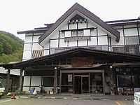
The structure
Sukayu Onsen (酸ヶ湯 Sukayu) is a well-known onsen (hot spring) in the city of Aomori, Aomori Prefecture. It is known for its "Sen-nin-buro" or "1,000-person bath", a large mixed gender public bath.
Climate
Sukayu Onsen is one of the snowiest inhabited places on Earth (possibly the snowiest) with an average yearly snowfall of 17.6m and a winter season record of 23.7m. It also holds the record of having the highest snow depth recorded at a JMA certified weather station of 566 cm, recorded on February 26, 2013.[1] Despite the high snowfall, Sukayu Onsen is accessible by road all year round.
| Climate data for Sukayu Onsen Averages (1981~2010) Records (1977~2012) | |||||||||||||
|---|---|---|---|---|---|---|---|---|---|---|---|---|---|
| Month | Jan | Feb | Mar | Apr | May | Jun | Jul | Aug | Sep | Oct | Nov | Dec | Year |
| Record high °C (°F) | 6.5 (43.7) |
10.6 (51.1) |
13.5 (56.3) |
21.1 (70) |
24.7 (76.5) |
27.0 (80.6) |
28.9 (84) |
30.8 (87.4) |
27.2 (81) |
22.4 (72.3) |
16.4 (61.5) |
11.3 (52.3) |
30.8 (87.4) |
| Average high °C (°F) | −5.1 (22.8) |
−4.7 (23.5) |
−0.7 (30.7) |
6.6 (43.9) |
12.6 (54.7) |
17.3 (63.1) |
20.6 (69.1) |
22.0 (71.6) |
17.3 (63.1) |
11.0 (51.8) |
4.1 (39.4) |
−2.1 (28.2) |
8.2 (46.8) |
| Daily mean °C (°F) | −7.6 (18.3) |
−7.2 (19) |
−3.9 (25) |
3.0 (37.4) |
8.7 (47.7) |
13.4 (56.1) |
17.2 (63) |
18.5 (65.3) |
13.7 (56.7) |
7.4 (45.3) |
0.9 (33.6) |
−4.8 (23.4) |
4.9 (40.8) |
| Average low °C (°F) | −10.4 (13.3) |
−10.1 (13.8) |
−7.3 (18.9) |
−0.7 (30.7) |
4.7 (40.5) |
9.6 (49.3) |
14.2 (57.6) |
15.4 (59.7) |
10.3 (50.5) |
3.9 (39) |
−2.3 (27.9) |
−7.5 (18.5) |
1.7 (35.1) |
| Record low °C (°F) | −17.8 (0) |
−17.3 (0.9) |
−14.9 (5.2) |
−10.9 (12.4) |
−4.4 (24.1) |
0.5 (32.9) |
5.0 (41) |
7.6 (45.7) |
0.0 (32) |
−4.8 (23.4) |
−13.8 (7.2) |
−18.0 (−0.4) |
−18.0 (−0.4) |
| Precipitation mm (inches) | — | — | — | — | 125.5 (4.941) |
128.6 (5.063) |
171.4 (6.748) |
197.3 (7.768) |
210.0 (8.268) |
194.9 (7.673) |
197.9 (7.791) |
151.4 (5.961) |
— |
| Snowfall cm (inches) | 459 (180.7) |
362 (142.5) |
238 (93.7) |
113 (44.5) |
56 (22) |
3 (1.2) |
0 (0) |
0 (0) |
0 (0) |
15 (5.9) |
154 (60.6) |
364 (143.3) |
1,764 (694.4) |
| Source: JMA[2] | |||||||||||||
References
External links
- Official website (Japanese)
Coordinates: 40°39′03″N 140°51′01″E / 40.65083°N 140.85028°E
This article is issued from Wikipedia. The text is available under the Creative Commons Attribution/Share Alike; additional terms may apply for the media files.