Subdivisions of Eritrea
From Wikipedia, the free encyclopedia
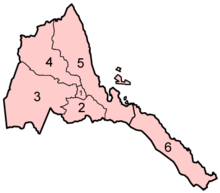
Eritrea is divided into six regions (zobas) and subdivided into districts ("sub-zobas"). The geographical extent of the regions is based on their respective hydrological properties. This a dual intent on the part of the Eritrean government: to provide each administration with sufficient control over its agricultural capacity, and to eliminate historical intra-regional conflicts.
The regions, followed by the sub-region, are:
| No. | Region (ዞባ) | Sub-region (ንኡስ ዞባ) |
|---|---|---|
| 1 | Central (ዞባ ማእከል) |
Berikh, Ghala-Nefhi, Semienawi Mibraq, Serejaka, Debubawi Mibraq, Semienawi Mi'erab, Debubawi Mi'erab |
| 2 | Southern (ዞባ ደቡብ) |
Adi Keyh, Adi Quala, Areza, Debarwa, Dekemhare, Mai Ayni, Mai Mne, Mendefera, Segeneiti, Senafe, Tserona |
| 3 | Gash-Barka (ዞባ ጋሽ ባርካ) |
Agordat, Barentu, Dghe, Forto, Gogne, Haykota, Logo-Anseba, Mensura, Mogolo, Molki, Guluj, Shambuko, Tesseney, La'elay Gash |
| 4 | Anseba (ዞባ ዓንሰባ) |
Adi Tekelezan, Asmat, Elabered, Geleb, Hagaz, Halhal, Habero, Keren City, Kerkebet, Sel'a |
| 5 | Northern Red Sea (ዞባ ሰሜናዊ ቀይሕ ባሕሪ) |
Afabet, Dahlak, Ghel'alo, Foro, Ghinda, Karura, Massawa, Nakfa, She'eb |
| 6 | Southern Red Sea (ዞባ ደቡባዊ ቀይሕ ባሕሪ) |
Are'eta, Central Dankalia, Southern Dankalia, Assab |
| |||||||||||
This article is issued from Wikipedia. The text is available under the Creative Commons Attribution/Share Alike; additional terms may apply for the media files.
