Strehla
From Wikipedia, the free encyclopedia
| Strehla | ||
|---|---|---|
 | ||
| ||
 Strehla | ||
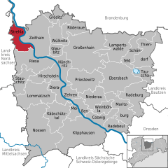
Location of Strehla within Meißen district 
 | ||
| Coordinates: 51°21′11″N 13°13′33″E / 51.35306°N 13.22583°ECoordinates: 51°21′11″N 13°13′33″E / 51.35306°N 13.22583°E | ||
| Country | Germany | |
| State | Saxony | |
| District | Meißen | |
| Subdivisions | 7 | |
| Government | ||
| • Mayor | Harry Güldner (CDU) | |
| Area | ||
| • Total | 30.07 km2 (11.61 sq mi) | |
| Elevation | 95 m (312 ft) | |
| Population (2012-12-31)[1] | ||
| • Total | 3,849 | |
| • Density | 130/km2 (330/sq mi) | |
| Time zone | CET/CEST (UTC+1/+2) | |
| Postal codes | 01616 | |
| Dialling codes | 035264 | |
| Vehicle registration | MEI | |
| Website | www.strehla.de | |
_by_J._Umbach.jpg)
Schloss Strehla in 19th century
Strehla is a small town in the district of Meißen, Saxony, Germany. It is located on the river Elbe, north of Riesa. This place name means arrow in Sorbian. Strehla includes the following subdivisions:
- Forberge
- Görzig/Trebnitz
- Großrügeln
- Lößnig
- Oppitzsch
- Paußnitz
- Unterreußen
History
Strehla was first mentioned in 1002. It is situated on the Via Regia Lusatiae Superioris (Royal road of Upper Lusatia), which connected Görlitz to Leipzig. The castle of Strehla belonged to the Pflugk family from the 14th century until 1945.
References
- ↑ "Statistisches Landesamt des Freistaates Sachsen – Bevölkerung des Freistaates Sachsen jeweils am Monatsende ausgewählter Berichtsmonate nach Gemeinden". Statistisches Landesamt des Freistaates Sachsen (in German). 17 June 2013.
External links
| Wikimedia Commons has media related to Strehla. |
| |||||||
This article is issued from Wikipedia. The text is available under the Creative Commons Attribution/Share Alike; additional terms may apply for the media files.
