Stregna
From Wikipedia, the free encyclopedia
| Stregna | |
|---|---|
| Comune | |
| Comune di Stregna | |
 | |
 Stregna | |
| Coordinates: 46°8′N 13°35′E / 46.133°N 13.583°ECoordinates: 46°8′N 13°35′E / 46.133°N 13.583°E | |
| Country | Italy |
| Region | Friuli-Venezia Giulia |
| Province | Province of Udine (UD) |
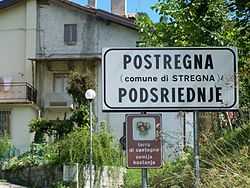
| Frazioni | Baiar (Bajar),Cernetig (Černeče), Clinaz (Klinac), Cobilza (Kobilca), Dughe (Duge), Gnidovizza (Gnjiduca), Oblizza (Oblica), Podgora (Podgora), Polizza (Polica), Ponte Clinaz (Klinški Malin), Postregna (Podsriednje), Presserie (Preserje), Raune (Raune), Saligoi (Šalguje), Tribil Inferiore (Dolenji Tarbij), Tribil Superiore (Gorenji Tarbij), Urataca, Varch (Varh) e Zamir (Zamir). |
| Government | |
| • Mayor | Mauro Veneto (Lista civica) |
| Area | |
| • Total | 19.7 km2 (7.6 sq mi) |
| Elevation | 404 m (1,325 ft) |
| Population (Dec. 2011) | |
| • Total | 404 |
| • Density | 21/km2 (53/sq mi) |
| Time zone | CET (UTC+1) |
| • Summer (DST) | CEST (UTC+2) |
| Postal code | 33040 |
| Dialing code | 0432 |
| Patron saint | Conversion of Paul the Apostle (St. Pauls' Day) |
| Saint day | January 25 |
| Website | Official website |
Stregna (Slovene: Srednje) is a comune (municipality) in the Province of Udine in the Italian region Friuli-Venezia Giulia, located about 60 km northwest of Trieste and about 30 km northeast of Udine, on the border with Slovenia, and borders the following municipalities: Grimacco, Kanal ob Soči (Slovenia), San Leonardo, and Prepotto. The name of the settlement comes from the Slovene word srednje, meaning "the middle one".
Stregna localities include:
- villages: Cernetig (Černeče), Clinaz (Klinac), Dughe (Duge), Gnidovizza (Gnjiduca), Oblizza (Oblica), Podgora (Podgora), Polizza (Polica), Postregna (Podsriednje), Presserie (Preserje), Raune (Raune), Saligoi (Šalguje), Tribil Inferiore (Dolenji Tarbij), Tribil Superiore (Gorenji Tarbij), Varch (Varh) e Zamir (Zamir);
- suburbs: Baiar (Bajar), Cobilza (Kobilca), Melina (Melina), Ponte Clinaz (Klinški Malin) e Urataca.[1]
As of December 31, 2004, it had a population of 434 and an area of 19.7 km².[2]
Ethnic composition
82.7% of the population were Slovenes according to the census 1971.[3]
Demographic evolution

References
- ↑ Municipal statute
- ↑ All demographics and other statistics: Italian statistical institute Istat.
- ↑ Thomas, Lee; Lokar A. (1977) Socioeconomic structure of the Slovene population in Italy, Slovene Studies Journal, Chicago, Illinois, p.28.
External links
This article is issued from Wikipedia. The text is available under the Creative Commons Attribution/Share Alike; additional terms may apply for the media files.