Stonesfield
| Stonesfield | |
 St. James the Great parish church |
|
 Stonesfield | |
| Population | 1,538 (2001 census)[1] |
|---|---|
| OS grid reference | SP3917 |
| Civil parish | Stonesfield |
| District | West Oxfordshire |
| Shire county | Oxfordshire |
| Region | South East |
| Country | England |
| Sovereign state | United Kingdom |
| Post town | Witney |
| Postcode district | OX29 |
| Dialling code | 01993 |
| Police | Thames Valley |
| Fire | Oxfordshire |
| Ambulance | South Central |
| EU Parliament | South East England |
| UK Parliament | Witney |
| Website | Stonesfield ~ Oxfordshire |
| |
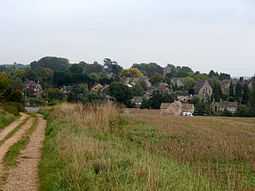
Stonesfield is a village and civil parish about 5 miles (8 km) north of Witney in Oxfordshire.
The village is on the crest of an escarpment. The parish extends mostly north and north-east of the village, in which directions the land rises gently and then descends to the Glyme at Glympton and Wootton about 3 miles (5 km) to the north-east. South of the Stonesfield, below the escarpment is the River Evenlode.
Archaeology
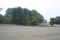
The course of Akeman Street Roman road forms part of the south-eastern boundary of the parish. In a field just east of the village is the site of a Roman villa that was very close to the Roman road.
A tenant farmer, George Handes (or Hannes), found the villa in 1712 when his plough revealed the remains of a Roman pavement[2] dating from the 3rd or 4th century AD.[3] One of its panels showed the Roman god Bacchus riding a panther.[4] Handes' landlord, Richard Fowler of Great Barrington, Gloucestershire, did not welcome the discovery[2] and he quarrelled with Handes over any profit to be had from excavating and displaying the pavement.[5]
The pavement immediately attracted the interest of the Oxford academic Thomas Hearne, soon followed by Bernard Gardiner.[6] However, in 1724 the pioneering archaeologist William Stukeley reported that Handes had destroyed the pavement as a result of the dispute with Fowler.[5] Nevertheless, in 1780 the antiquarian Daines Barrington reported that much of the room and pavement found in 1712 still survived and a second, smaller room with a tesselated floor was being excavated.[5] At the same time parts of the villa's baths were also excavated.[5] In 1789 Richard Gough reported in his new edition of William Camden's Britannia that much of the pavement had been destroyed.[3]
In 1801 Stonesfield's common lands were enclosed and the division of land caused further damage to the remains of the villa.[3] In 1813 the antiquarian James Brewer reported in the Oxfordshire volume of his The Beauties of England and Wales that only fragments of the pavement found in 1712 had survived destruction.[7] In 1826 the Ashmolean Museum acquired hypocaust flue-tiles from the site and the base of a pillar that may also be from the hypocaust.[8] In 1836 a small coin from the reign of the 4th century Emperor Valentinian was found.[8]
In 1858 a visitor called Akerman learnt that the remains of the villa had been totally destroyed.[8] During the Second World War aerial archaeology discovered a number of Roman and other archaeological sites in this part of Oxfordshire. However, despite repeated attempts in different seasons and under different crop conditions, aerial archaeology has found no surviving trace of the villa at Stonesfield.[8]
About 1 mile (1.6 km) south of Stonesfield, on the other side of the River Evenlode and in the next parish, the remains of North Leigh Roman Villa survive in the care of English Heritage.
History


Stonesfield is mentioned in the Domesday Book when its toponym was Stunsfeld (meaning "fools field"). This was because of the stony nature of the soil in the area, so the mutation of the name is most appropriate. Thomas Hearne used the spelling "Stunsfield" in 1712[2] and Akerman spelt it "Stuntesfield" in 1854.[8]
In 1743 a clock was installed in the Church of England parish church of St. James.[9] It was said to have been made for a local manor house in 1543, and transferred to the church after the house was demolished.[9] The clock has since been moved from Stonesfield, rebuilt, and installed at Judd's Garage at Wootton.[9]
Until the 20th century Stonesfield was the source of Stonesfield slate; a type of Cotswold stone slate that is common on the roofs of older buildings in the Cotswolds and Oxfordshire. Many of the older buildings of the University of Oxford have Stonesfield slate roofs.
The first fossil bones to be described as those of a dinosaur of the genus Megalosaurus were found close to Stonesfield and named in 1824 by William Buckland. The slate-mining activities unearthed many finds in succeeding years.[citation needed]
During the 1960s and 1970s new houses were built on the eastern side of the village. Most of these and all of the old cottages and larger modern houses in the original part of the village are now unaffordable to the children of locals, many of whom consequently have moved out of the area.
Notable people
- Basil Eastwood, British Ambassador (Syria 1996–2000; Switzerland 2001–04), lived in Stonesfield until retirement, and founded the charity Cecily's Fund in the village. A Cecily's Day picnic is held every year in Stonesfield Manor.
- Nicholas Hooper, composer, has lived in Stonesfield since the 1980s.
- Robert Sherlaw Johnson, composer, lived in Stonesfield from the late 1960s until his death in 2000.
- Caroline Lucas, leader of the Green Party of England and Wales, lived in Stonesfield until her election as an MEP in 1999.
- Walter Padbury, the Australian pioneer and philanthropist who arrived in Western Australia in February 1830, was born in Stonesfield.
Transport
The nearest railway station is at Charlbury on the Cotswold Line. An hourly bus service between Charlbury, Woodstock and Oxford serves Stonesfield. Worths' Coaches of Enstone operated the route from the 1920s until 2004, when Oxfordshire County Council awarded the contract to Stagecoach in Oxfordshire.
Sport
The village actively encourages youth sport and the Stonesfield Strikers Football Club run a number of mixed gender and girls-only youth football teams and want to ensure they develop young players in a safe and positive environment that encourages fun, friendship, fairness and respect.
References
- ↑ "Area: Stonesfield CP (Parish): Parish Headcounts". Neighbourhood Statistics. Office for National Statistics. Retrieved 16 March 2010.
- ↑ 2.0 2.1 2.2 Taylor 1941, p. 1.
- ↑ 3.0 3.1 3.2 Taylor 1941, p. 7.
- ↑ Taylor 1941, p. 9.
- ↑ 5.0 5.1 5.2 5.3 Taylor 1941, p. 6.
- ↑ Taylor 1941, p. 1–3.
- ↑ Taylor 1941, p. 7–8.
- ↑ 8.0 8.1 8.2 8.3 8.4 Taylor 1941, p. 8.
- ↑ 9.0 9.1 9.2 Beeson & Simcock 1989, p. 67.
Sources and further reading
- Beeson, C.F.C. (1989) [1962]. Simcock, A.V., ed. Clockmaking in Oxfordshire 1400–1850 (3rd ed.). Oxford: Museum of the History of Science. p. 67. ISBN 0-903364-06-9.
- Crossley, Alan (ed.); Baggs, A.P.; Colvin, Christina; Colvin, H.M.; Cooper, Janet; Day, C.J.; Selwyn, Nesta; Tomkinson, A. (1983). A History of the County of Oxford, Volume 11: Wootton Hundred (northern part). Victoria County History. pp. 181–194.
- Sherwood, Jennifer; Pevsner, Nikolaus (1974). Oxfordshire. The Buildings of England. Harmondsworth: Penguin Books. pp. 790–791. ISBN 0-14-071045-0.
- Taylor, M.V. (1941). "The Roman Tessellated Pavement at Stonesfield, Oxon.". Oxoniensia (Oxford Architectural and Historical Society) VI: 1–8.
External links
![]() Media related to Stonesfield at Wikimedia Commons
Media related to Stonesfield at Wikimedia Commons
