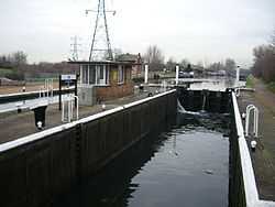
Stonebridge Lock
From Wikipedia, the free encyclopedia
| Stonebridge Lock | |
|---|---|
 Stonebridge Lock | |
| Waterway | River Lea Navigation |
| County |
London Borough of Haringey Greater London |
| Maintained by | British Waterways |
| Operation | Mechanical/Manual |
| Length | 95 feet (29 m) |
| Width | 19 feet 6 inches (5.9 m) |
| Fall | 6 feet 6 inches (2 m) |
| Distance to Bow Creek | 8.3 miles (13.4 km) |
| Distance to Hertford Castle Weir | 19.7 miles (31.7 km) |
| Geographic data | |
| Coordinates | 51°35′50″N 0°03′02″W / 51.597106°N 0.050517°WCoordinates: 51°35′50″N 0°03′02″W / 51.597106°N 0.050517°W |
Stonebridge Lock (No16) is a paired lock on the River Lee Navigation in the London Borough of Haringey, England and is located near Tottenham, London. Like other locks as far as Ponder's End Lock it is large enough to take barges of up to 130 tons. The primary lock has been upgraded to mechanical operation, but the secondary lock is operated manually.
Access to the lock
The lock is situated on the navigation between the Lockwood Reservoir on the Walthamstow side and Tottenham Marshes on the Tottenham side. The lock can be reached on foot only from Marsh Lane behind Northumberland Park railway station.
Pedestrian and cycle access via the towpath which forms part of the Lea Valley Walk
External links
| Next lock upstream | River Lea Navigation | Next lock downstream |
| Pickett's Lock 2.2 miles |
Stonebridge Lock Grid reference: TQ3501290548 |
Tottenham Lock 0.9 miles |
| ||||||||||||||||||||
This article is issued from Wikipedia. The text is available under the Creative Commons Attribution/Share Alike; additional terms may apply for the media files.