Stockstadt am Main
| Stockstadt a.Main | ||
|---|---|---|
| ||
 Stockstadt a.Main | ||
Location of Stockstadt a.Main within Aschaffenburg district  | ||
| Coordinates: 49°58′47″N 09°03′50″E / 49.97972°N 9.06389°ECoordinates: 49°58′47″N 09°03′50″E / 49.97972°N 9.06389°E | ||
| Country | Germany | |
| State | Bavaria | |
| Admin. region | Unterfranken | |
| District | Aschaffenburg | |
| Government | ||
| • Mayor | Peter Wolf[1] (CSU) | |
| Area | ||
| • Total | 18.86 km2 (7.28 sq mi) | |
| Elevation | 117 m (384 ft) | |
| Population (2012-12-31)[2] | ||
| • Total | 7,652 | |
| • Density | 410/km2 (1,100/sq mi) | |
| Time zone | CET/CEST (UTC+1/+2) | |
| Postal codes | 63809-63811 | |
| Dialling codes | 06027 | |
| Vehicle registration | AB | |
| Website | www.stockstadt-am-main.de | |
Stockstadt am Main (officially: Stockstadt a.Main) is a market community in the Aschaffenburg district in the Regierungsbezirk of Lower Franconia (Unterfranken) in Bavaria, Germany.
Geography
Location
Stockstadt am Main lies on Aschaffenburg’s western town limit on the Main’s left bank. To Stockstadt’s west and northwest runs the boundary with Hesse, and southwest of Stockstadt lies the Bachgau.
Neighbouring communities
To the south is the community of Großostheim, and to the southwest, beyond the state boundary, in Hesse, lies Babenhausen; northwest lie Mainhausen and Seligenstadt.
The nearest neighbouring communities are Kleinostheim to the north and Mainaschaff to the east.
History
Stockstadt am Main had its first documentary mention as early as the ninth century, if only through some townsmen who were obliged to pay taxes. These are listed as living in Stocestat, as the community was known then.
Eventually the community itself was named in writing for the first time in 1024. Stoddenstat was donated to Fulda Abbey by Henry II, Holy Roman Emperor. This lasted until 1309, when Stockstadt was given to the Archbishopric of Mainz.
In the Middle Ages the surrounding forests belonged to the Dreieich Royal Hunting Forest (Wildbann Dreieich), which also had one of its 30 Wildhuben (farming estates whose owners were charged with guarding the king’s hunting rights) in Stockstadt.
Politics
Community council
The council is made up of 21 council members, counting the fulltime mayor.
| CSU | SPD | Freie Wählergemeinschaft | Total | |
| 2002 | 7 | 10+1(mayor) | 3 | 21 seats |
| 2008 | 10+1(mayor) | 7 | 3 | 21 seats |
(as at municipal election held on 2 March 2008)
Town partnerships
 Saint-André-sur-Orne, Calvados, France
 Saint-Martin-de-Fontenay, Calvados, France
 May-sur-Orne, Calvados, France
Coat of arms
The community’s arms might be described thus: Azure a fess wavy abased argent above which a legionnaire’s helmet of the second crested gules in profile.
Sightseeing

- The Zollhaus (“Customs House”) on Hauptstraße long served the Elector-Archbishop of Mainz Albrecht von Brandenburg. It was built between 1514 and 1545.
- The Leonharduskirche (Saint Leonard’s Church) is likewise found in the old centre of Stockstadt and goes back to the year 1773.
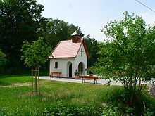
- The St. Anna-Kapelle originally stood on the corner of Hauptstraße and Alter Stadtweg. It was torn down in January 1925 as a result of a decision by community council. In 2007, the chapel was rebuilt on the historical model at another site to the west beyond Bundesstraße 469 towards Auhof, and dedicated on 6 April 2008.
References
- ↑ www.statistik.bayern.de
- ↑ "Fortschreibung des Bevölkerungsstandes". Bayerisches Landesamt für Statistik und Datenverarbeitung (in German). 31 December 2012.
External links
| Wikimedia Commons has media related to Stockstadt am Main. |
