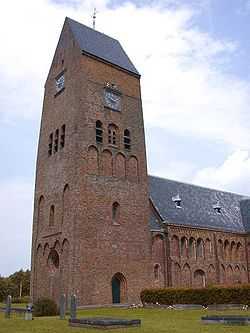
Stedum
From Wikipedia, the free encyclopedia
| Stedum | ||
|---|---|---|
 Bartholomeuskerk in Stedum | ||
| ||
| Coordinates: 53°19′21″N 6°41′45″E / 53.32250°N 6.69583°E | ||
| Country | Netherlands | |
| Province | Groningen | |
| Municipality | Loppersum | |
| Population (1 January 2006) | 1,100 | |
Stedum is
- a village in the Dutch province of Groningen. It is located in the municipality of Loppersum, about 15 km northeast of the city of Groningen.
- Stedum was a separate municipality until 1990, when it was merged with Loppersum.[1]
- is a village in Lower Saxony (Germany) belongs to the Hohenhameln Community; about 30 km south of Hanover, 14 km east of Hildesheim and 11 km west of Peine
Worth mentioning is that the German Hohenhameln Community is twinned with the Dutch Community Loppersum.
References
- ↑ Ad van der Meer and Onno Boonstra, Repertorium van Nederlandse gemeenten, KNAW, 2006.
- ↑ WEB-site of the community Hohenhameln
- ↑ Homepage of A+B Peine
External links
- J. Kuyper, Gemeente Atlas van Nederland, 1865-1870, "Stedum". Map of the former municipality, around 1868.
Coordinates: 53°19′N 6°42′E / 53.317°N 6.700°E
This article is issued from Wikipedia. The text is available under the Creative Commons Attribution/Share Alike; additional terms may apply for the media files.
