St Madoes
From Wikipedia, the free encyclopedia
Coordinates: 56°22′31″N 3°18′12″W / 56.375335°N 3.303373°W
| St Madoes | |
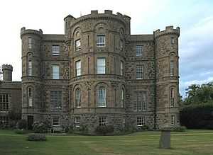 Pitfour Castle, St Madoes, designed by Robert Adam, 1764 |
|
 St Madoes | |
| Population | 1,263 |
|---|---|
| OS grid reference | NO196211 |
| - Edinburgh | 47 mi (76 km) |
| - London | 364 mi (586 km) |
| Council area | Perth and Kinross |
| Lieutenancy area | Perth and Kinross |
| Country | Scotland |
| Sovereign state | United Kingdom |
| Post town | PERTH |
| Postcode district | PH2 |
| Dialling code | 01738 |
| Police | Scottish |
| Fire | Scottish |
| Ambulance | Scottish |
| EU Parliament | Scotland |
| Scottish Parliament | North Tayside |
| North East Scotland | |
St Madoes is a village in the Carse of Gowrie in Scotland, developed around Pitfour Castle. It is believed, however, that there has been settlements in the beginning of the century due to the discovery of several standing stones, as well as the St Madoes stone, a well preserved Pictish cross.
In terms of local amenities St Madoes has a small shop, two parks, a primary school and an 18th-century church built upon earlier remains. Recently the village has started expanding due to the building of a large housing estate.
It is located near Errol, between Dundee and Perth.
See also
External links
This article is issued from Wikipedia. The text is available under the Creative Commons Attribution/Share Alike; additional terms may apply for the media files.