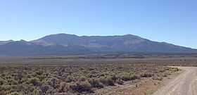
Spruce Mountain (Nevada)
| Spruce Mountain | |
|---|---|
 | |
| Elevation | 10,267 ft (3,129 m) NAVD 88[1] |
| Prominence | 3,930 ft (1,198 m)[2] |
| Location | |
 Spruce Mountain | |
| Range | Pequop Mountains |
| Coordinates | 40°33′08″N 114°49′18″W / 40.552101286°N 114.821721172°WCoordinates: 40°33′08″N 114°49′18″W / 40.552101286°N 114.821721172°W[1] |
| Topo map | USGS Spruce Mountain, NV |
Spruce Mountain is a mountain in Elko County, in the northeastern section of Nevada in the Great Basin region of the western United States. The summit is at 10,267 feet (3,129 m). Spruce Mountain is on a northeast–southwest trending ridge with a parallel Spruce Ridge to the northwest. To the east a low section of hills connects the mountain to the south end of the Pequop Mountains.[3] US Route 93 passes the southwest end of the mountain.
The western side of the mountain was the site of copper, silver, and lead mining during the late 1800s. The settlement of Sprucemont on the western slope of the mountain supported the mining activity and existed from 1868 through about 1900 and is now a ghost town.[4] Electronics researcher Ralph Hartley was born at Sprucemont in 1888.

References
- ↑ 1.0 1.1 "Spruce Mtn". NGS data sheet. U.S. National Geodetic Survey. Retrieved 2011-05-20.
- ↑ "Spruce Mountain, Nevada". Peakbagger.com. Retrieved 2014-01-29.
- ↑ DeLorme Atlas and Gazeteer: Nevada, DeLorme, 8th ed., 2012, p. 33 ISBN 0-89933-334-6
- ↑ "Spruce Mountain". ghosttowns.com. Retrieved 2009-12-09.
External links
- "Spruce Mountain (NV)". SummitPost.org. http://www.summitpost.org/page/440046.
| Wikimedia Commons has media related to Spruce Mountain, Nevada. |