Spring Bluff, Queensland
| Spring Bluff Toowoomba, Queensland | |||||||||||||
|---|---|---|---|---|---|---|---|---|---|---|---|---|---|
 Spring Bluff railway station | |||||||||||||
| Coordinates | 27°27′43″S 151°58′44″E / 27.462°S 151.979°ECoordinates: 27°27′43″S 151°58′44″E / 27.462°S 151.979°E | ||||||||||||
| Established | 1860s | ||||||||||||
| Postcode(s) | 4352 | ||||||||||||
| Location | 14 km (9 mi) NNE of Toowoomba | ||||||||||||
| LGA(s) | Toowoomba Region | ||||||||||||
| State electorate(s) | Toowoomba North | ||||||||||||
| Federal Division(s) | Groom | ||||||||||||
| |||||||||||||
Spring Bluff is a locality north of Toowoomba, Queensland. It is situated 15 kilometres (9 mi) north of the city centre via New England Highway, and is adjacent to the town of Highfields.
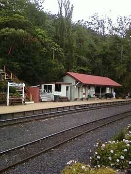
The area is named after a railway station in the area, which was built in the 1860s to allow trains a place to stop during the steep climb from Brisbane to nearby Toowoomba. In 1890, it was named Spring Bluff after the spring water and the sandstone bluff in the area.[1]
The railway station, which with its gardens is heritage listed, is maintained by a trust consisting of the regional councils of Toowoomba and Lockyer Valley along with Queensland Rail, who also operate a cafe at the site. Due to the floods at nearby Murphys Creek in early 2011, the station is closed for repairs.[2]
References
- ↑ Department of Environment and Resource Management. "Place name details — Spring Bluff". Retrieved 4 June 2011.
- ↑ Spring Bluff Railway Station Trust (2011). "Spring Bluff Railway Station". Retrieved 5 June 2011.