Spanish Guinea
From Wikipedia, the free encyclopedia
| Spanish Territories of the Gulf of Guinea Territorios Españoles del Golfo de Guinea | ||||||
| Spanish colony | ||||||
| ||||||
| ||||||
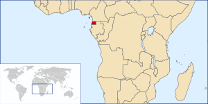
 Location of Spanish Guinea in central Africa. | ||||||
| Capital | Santa Isabel (now Malabo) | |||||
| Languages | Spanish | |||||
| Political structure | Colony | |||||
| Governor | ||||||
| - | 1962–1963 (last) | Francisco Núñez Rodríguez | ||||
| High Commissioner | ||||||
| - | 1963–1964 (first) | Francisco Núñez Rodríguez | ||||
| - | 1966–1968 (last) | Víctor Suances Díaz del Río | ||||
| Historical era | 20th century | |||||
| - | Established | 11 August 1926 | ||||
| - | Independence | 12 October 1968 | ||||
| Currency | Spanish Guinea peseta | |||||

Coat of arms of the Spanish Río Muni colony.
Spanish Guinea (Spanish: Guinea Española) was a Spanish colony in Africa that became the independent nation of Equatorial Guinea.
History
Main article: History of Equatorial Guinea
The population of the colony was stratified[1] as:
- Whites, whose immigration was regulated by the Spanish government.
- Emancipados, black population assimilated to the whites. They had a Christian Spanish education. Some of them descended from freed Cuban slaves, brought to Africa by Royal Orders of September 13, 1845, (voluntary) and June 20, 1861, (deportation). This group included mestizos (mulattoes) acknowledged by a white father.[2]
- "Individuals of colour" under patronage, the majority of the black indigenous people, of different ethnic groups, mostly Bantus. They were not allowed to own property and were liable to forced labour. They included unacknowleged mestizos.
- Others (Nigerian, Cameroonian, Chinese, Indian).
References
- ↑ Anuario del Instituto Cervantes (2005). Panorama de la literatura en español en Guinea Ecuatorial, Justo Bolekia Boleká, Introducción histórica
- ↑ Espacio, Tiempo y Forma, Serie V, Hª Contemporánea, t. 11, 1998, págs. 113-138, Penología e indigenismo en la antigua Guinea española, Pedro María Belmonte Medina
See also
- History of Equatorial Guinea
- Annobón
- Bight of Bonny
- Bioko Island
- Cameroon line
- Equatorial Guinea
- Fernando Po
- Gulf of Guinea
- São Tomé and Príncipe
- Bubi
- Fernandinos
- Emancipados
- Spanish Africa
Coordinates: 1°35′N 10°21′E / 1.583°N 10.350°E
This article is issued from Wikipedia. The text is available under the Creative Commons Attribution/Share Alike; additional terms may apply for the media files.
.svg.png)
.svg.png)