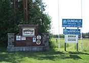
Southgate, Ontario
| Southgate | |
|---|---|
| Township | |
 | |
 Southgate | |
| Coordinates: 44°06′N 80°35′W / 44.100°N 80.583°WCoordinates: 44°06′N 80°35′W / 44.100°N 80.583°W | |
| Country |
|
| Province |
|
| County | Grey |
| Formed | January 1, 2000 |
| Government | |
| • Mayor | Brian Milne |
| • Federal riding | Bruce—Grey—Owen Sound |
| • Prov. riding | Bruce—Grey—Owen Sound |
| Area[1] | |
| • Land | 644.35 km2 (248.78 sq mi) |
| Population (2011)[1] | |
| • Total | 7,190 |
| • Density | 11.2/km2 (29/sq mi) |
| Time zone | EST (UTC-5) |
| • Summer (DST) | EDT (UTC-4) |
| Postal Code | N0C 1B0 |
| Area code(s) | 519 and 226 |
| Website | www.southgate.ca |
Southgate is a township in western Ontario, Canada, in the southeast corner of Grey County. Southgate was formed on January 1, 2000, when the Village of Dundalk, the Township of Proton and the Township of Egremont were amalgamated. The headwaters of the South Saugeen, Beatty Saugeen and Grand Rivers are located in Southgate.
Communities

The township comprises the communities of Bethel, Birdell, Boothville, Cedarville, Conn, Dromore, Dundalk, Egerton, Gildale, Holstein, Hopeville, Keldon, Kingscote, Landerkin, Proton Station, Robbtown, Signet, Swinton Park, Tartan, Thistle, Varney, Ventry and Yeovil.
Infrastructure
The former rail line roadbed has become a snowmobile trail sponsored by the federal government. Dundalk's three elementary schools are Egremont Community School, Dundalk & Proton Community School and Highpoint Community School. The high school is Grey Highlands Secondary School, which is located in the nearby town of Flesherton.
Economy
Primary industry, in the form of agriculture is the dominant sector of the economy in Southgate. The service sector thrives and several commercial and industrial operations exist, including auto parts manufacturer Metal Systems of Canada and several small businesses. The township has purchased 220 acres (89 ha) to expand the existing 5-10 acre industrial park. Currently 46 acres are available for industrial development.
Culture
Southgate has several churches representing Catholic, Anglican, Protestant and Mennonite denominations. Dundalk hosts an annual square dance, step dance and clogging competition on the third weekend in June every year. Visitors from all over the country participate in the dance competitions, take in the parade and camp in nearby Dundalk Memorial Park.
The Dundalk fall fair is still a big event too.
The Village of Holstein is home to the Egremont Optimists and Holstein Drama Club. It hosts several events each year including the Holstein Maple Fest, a Canada Day fireworks display, the Holstein Rodeo, Holstein Santa Claus Parade and annual drama productions. Notable landmarks and businesses in Holstein are the Holstein General Store, Holstein Feed Mill, Holstein Park and Dam, Egremont Optimist's Community centre, Holstein Cenotaph, Knox Holstein Presbyterian Church and Egremont Community School.
Holstein's Maple Fest is hosted at Love's SugarBush each April and features displays of pioneer activities, modern production of maple syrup, games, booths from local merchants, artists and local community groups and has featured live shows from the 'Canadian Raptor Conservancy' and children's entertainer 'Dickie Bird'.
The Holstein Rodeo is hosted at the A Bar K Ranch near Holstein each July in co-operation with the Egremont Optimists. It is a 3 day event featuring live concerts with both 'Age of Majority' and 'All ages' areas each evening, live rodeo events, booths for local vendors and community groups and a variety of meal options.
Demographics
| |||||||||||||||||
Population trend:[4]
- Population in 2011: 7190
- Population in 2006: 7167 (or 7072 when adjusted to 2011 boundaries)
- Population in 2001: 6907
- Population total in 1996: 6449
- Village of Dundalk: 1776
- Township of Egremont: 2679
- Township of Proton: 2005
- Population total in 1991: 6012
- Village of Dundalk: 1677
- Township of Egremont: 2485
- Township of Proton: 1850
Notable residents
- Samuel Lewis Honey - Conn born recipient of the Victoria Cross for actions during battle of the Canal du Nord during the First World War
See also
References
- ↑ 1.0 1.1 1.2 "Southgate census profile". 2011 Census of Population. Statistics Canada. Retrieved 2012-03-15.
- ↑ "2006 Community Profiles". Canada 2006 Census. Statistics Canada. March 30, 2011. Retrieved 2012-03-15.
- ↑ "2001 Community Profiles". Canada 2001 Census. Statistics Canada. February 17, 2012. Retrieved 2012-03-15.
- ↑ Statistics Canada: 1996, 2001, 2006 census
External links
 |
Grey Highlands |  | ||
| West Grey | |
Melancthon | ||
| ||||
| | ||||
| Wellington North | East Luther-Grand Valley |