Southern Administrative Okrug
Coordinates: 55°38′N 37°40′E / 55.633°N 37.667°E
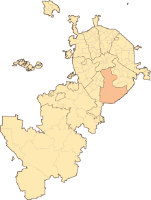
Southern Administrative Okrug, or Yuzhny Administrative Okrug (Russian: Ю́жный администрати́вный о́круг), is one of the twelve administrative okrugs of Moscow. It was founded in 1991 and has an area of 132 square kilometers (51 sq mi). District's population: 1,716,808 (2010 Census);[1] 1,593,065 (2002 Census).[2]
The okrug is bordered by Leninsky Avenue in the north, the Moscow Ring Road in the south, by the valley of the Moskva River in the east, and by the river valley and a part of Kotlovka Bitsevsky forest in the west.[3]
History
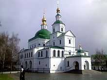
The territory that comprises modern Southern Administrative Okrug attracted settlers from time immemorial, even in spite of the fact that it has historically been an unsafe area where enemies would attack first. In order to protect the borders, powerful monasteries were built. The first of them was Danilov Monastery, founded in 1271 by Prince Daniil of Moscow.
In 1593, the Donskoy Monastery was established to commemorate the victory over Khan Kazi-Girei. Near the monastery, along the roads of the villages and hamlets, began to emerge Verkhniye and Nizhniye Kotly, Sadovniki, Nagatino, Kotlyakovo, Chertanovo, Annino, Biryulyovo, Tsaritsyno, Borisova, Orekhovo, and others. All of these names are preserved today in the okrug. Kolomna was one of the first villages to appear in the area. Urban development in the area began to emerge later in the 16th–17th centuries along with the architectural ensemble Kolomenskoye.
Today the okrug encompasses architecture known around the world, such as the Church of the Ascension, which is listed by UNESCO as a World Heritage Site.[4]
Districts
The okrug is divided into sixteen districts:
- Biryulyovo Vostochnoye
- Biryulyovo Zapadnoye
- Brateyevo
- Chertanovo Severnoye
- Chertanovo Tsentralnoye
- Chertanovo Yuzhnoye
- Danilovsky
- Donskoy
- Moskvorechye-Saburovo
- Nagatino-Sadovniki
- Nagatinsky zaton
- Nagorny
- Orekhovo-Borisovo Severnoye
- Orekhovo-Borisovo Yuzhnoye
- Tsaritsyno
- Zyablikovo
References
- ↑ "Всероссийская перепись населения 2010 года. Том 1" [2010 All-Russian Population Census, vol. 1]. Всероссийская перепись населения 2010 года (2010 All-Russia Population Census) (in Russian). Federal State Statistics Service. 2011. Retrieved June 29, 2012.
- ↑ "Численность населения России, субъектов Российской Федерации в составе федеральных округов, районов, городских поселений, сельских населённых пунктов – районных центров и сельских населённых пунктов с населением 3 тысячи и более человек" [Population of Russia, its federal districts, federal subjects, districts, urban localities, rural localities—administrative centers, and rural localities with population of over 3,000]. Всероссийская перепись населения 2002 года (All-Russia Population Census of 2002) (in Russian). Federal State Statistics Service. May 21, 2004. Retrieved February 9, 2012.
- ↑ About Southern Administrative Okrug Retrieved on October 30, 2009 (Russian)
- ↑ (Russian)History of the Southern Administrative Okrug Retrieved on October 30, 2009
External links
| ||||||||||||||||||||||||||||||||||||||||
