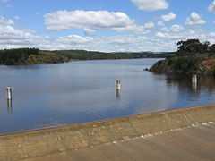
South Para Reservoir
| South Para Reservoir | |
|---|---|
 South Para Reservoir. | |
| Location | South Australia |
| Coordinates | 34°41′49″S 138°51′40″E / 34.697°S 138.861°ECoordinates: 34°41′49″S 138°51′40″E / 34.697°S 138.861°E |
| Type | reservoir |
| Basin countries | Australia |
| Surface area | 4 km² |
South Para Reservoir is the second largest reservoir in South Australia, behind Mount Bold Reservoir, and the principal reservoir of the South Para River system. The reservoir's large capacity of around 45,330 megalitres and its location in the catchment area mean that it only ever fills completely once in every five years.
Costing A$6.4 million, the reservoir took almost a decade to construct, between 1949 and 1958, due to a demand on resources in the post-war boom. The building of the historic Mannum-Adelaide Pipeline from the River Murray to the water-short city of Adelaide was a key delay in South Para's construction; that Pipeline today disperses water into the reservoir.
The Reservoir is surrounded by nature reserve and has been a focus for two major revegetation projects, the first in the late 1950s when over 5000 trees and shrubs were planted, and the second as part of the South Australian Government's "Million Trees" initiative.
- Capacity: 45,330 ML
- Length of wall: 284 m
- Height of wall: 44.2 m
- Type of wall: rolled fill
Gallery
-

The Reservoir's spillway.
-

Panoramic view of South Para Reservoir and its bushland surrounds.
-

Water levels in September 2009
-

Bridge over spillway.
-

South Para Reservoir
-

South Para Reservoir
See also
- List of reservoirs and dams in Australia