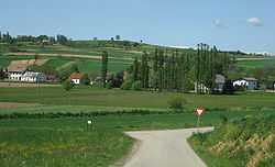
Sotina
From Wikipedia, the free encyclopedia
| Sotina | |
|---|---|
 | |
_location_map.svg.png) Sotina | |
| Coordinates: 46°49′43.68″N 16°2′37.7″E / 46.8288000°N 16.043806°ECoordinates: 46°49′43.68″N 16°2′37.7″E / 46.8288000°N 16.043806°E | |
| Country |
|
| Traditional region | Prekmurje |
| Statistical region | Mura |
| Municipality | Rogašovci |
| Area | |
| • Total | 4.36 km2 (1.68 sq mi) |
| Elevation | 257.5 m (844.8 ft) |
| Population (2002) | |
| • Total | 394 |
| [1] | |
Sotina (Hungarian: Hegyszoros, German: Stadelberg) is a village in the Municipality of Rogašovci in the Prekmurje region of northeastern Slovenia.[2] The village includes the following hamlets: Bezovkova Graba, Maribor (a small Roma settlement), Bracov Dol, Činčov Breg, Kolarova Graba, Majcov Mlin, Martinova Graba, Patrov Breg, Tomanov Breg, and Turzov Breg.[3]
References
- ↑ Statistical Office of the Republic of Slovenia
- ↑ Rogašovci municipal site
- ↑ Savnik, Roman, ed. 1980. Krajevni leksikon Slovenije, vol. 4. Ljubljana: Državna založba Slovenije. p. 319.
External links
| |||||||||||||
This article is issued from Wikipedia. The text is available under the Creative Commons Attribution/Share Alike; additional terms may apply for the media files.
