Sorikmarapi
From Wikipedia, the free encyclopedia
| Sorikmarapi | |
|---|---|
 | |
| Elevation | 2,145 m (7,037 ft)[1] |
| Location | |
| Location | Sumatra, Indonesia |
| Coordinates | 0°41′10″N 99°32′20″E / 0.686°N 99.539°E |
| Geology | |
| Type | stratovolcano |
| Last eruption | 1986 or 1996(?) |
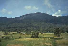
Sorikmarapi is highly vegetated stratovolcano on Sumatra island, Indonesia. It has 600 m wide of crater lake at the summit and some sulfur deposits. Small parasitic crater, called Danau Merah, is found at the upper southeast flank of the mountain and several solfatara fields at the eastern flank. During the 19th and 20th century, small phreatic eruptions occurred.[1]
See also
References
- ↑ 1.0 1.1 "Sorikmarapi". Global Volcanism Program, Smithsonian Institution. http://www.volcano.si.edu/world/volcano.cfm?vnum=0601-12%3D. Retrieved 2006-12-19.
This article is issued from Wikipedia. The text is available under the Creative Commons Attribution/Share Alike; additional terms may apply for the media files.