Soline, Sali
| Soline | |
|---|---|
| Village | |
 | |
| Country |
|
| County | Zadar County |
| Municipality | Sali |
| Population (2011)[1] | |
| • Total | 38 |
| Time zone | CET (UTC+1) |
| • Summer (DST) | CEST (UTC+2) |
| Area code(s) | 23000 |
| Website | https://www.facebook.com/groups/4214848844/ |
Soline is a small Croatian village on the island of Dugi otok. It is divided into two bodies of land: Bura and Japar, located on Solišćica Luka Bay. The village was named after the old salt pans that are in the bay.
Soline was first mentioned in documents that date back to 1114 C.E., making it one of the oldest settlements on Dugi otok.
Population
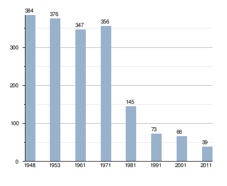
In 1527 the records showed that Soline, along with neighboring towns Bozava and Veli, had a total of 225 residents. Since then the population has fluctuated as follows:
- 1818 - 150
- 1843 - 189
- 1856 - 227
- 1873 - 256
- 1890 - 325
- 1900 - 366
- 1913 - 395
- 1927 - 400
- 1948 - 386
- 1953 - 376
- 1981 - 145
The population listed in 2011 was 39 with a total number of 26 households. There are 100 housing units in Soline and 46 permanent apartments.
| Village | 1948. | 1953. | 1961. | 1971. | 1981. | 1991. | 2001. | 2011. |
|---|---|---|---|---|---|---|---|---|
| Soline | 384 | 376 | 347 | 356 | 145 | 73 | 66 | 38 |
Population trends 1857-2011[2]

History
Geography
Economy and tourism
Chief occupations include farming, grape cultivation for wine making, olive growing, fruit growing, and fishing. In recent years, tourism and hospitality services have rapidly developed on the regional road running along Dugi Island from the village of Sali on the south end to Božava and Veli Rat on the north end.
Monuments
Church of St. Jacob

Glagolitic madrikula St. Jacob
Glagolitic madrikula St. Jacob is also the way in which the priests of Soline keep track of the Brotherhood of St. Jacob and the rules of the confraternity (chapters) carried out in practice. The whole madrikula is written in Croatian language, cursive Glagolitic, and a little Latin. In this madrikuli there is also the data for two schools whose records did not survive.

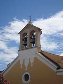
Church Bells
On the facade of the parish church of St. Jacob rises an antique white tower. In 1923, two bells were placed on it. On the larger bell inscriptions read: "Lady of the Rosary, St. Fabian and Sebastian, pray for us!" Acquired Parish Solinksa pastorate Don Srećko Pavic. The other bell bears the inscription: "Solin - St. Jacob. Jacob Bell Foundry Cukrov - Split - 1923 Lightning and thunder, deliver us, O Lord!"
Beaches
Solišćica beach is a popular swimming spot on the bay. Another popular location, Sakarun beach is a 400 meter stretch of white sand located south of the village on the inside of Sakarun Cove. There is a bar and a bakery located on the beach. This beach is known to be one of the most beautiful beaches on the Adriatic Sea.
Transportation
The main road on Dugi took links Soline with other towns on the island and the ferry port in Bribinj. There are also year-round shipping links with the mainland and seasonal connections to Ancona, Italy. Ferry connections to Jadrolinija with a capacity of 70 cars are maintained by M / T Vladimir Nazor. A direct connection between Zader on the mainland and neighboring Bozava on Dugi took is maintained by the catamaran "Paula" run by shippers G & H Lines. A bus line connects the towns on Dugi Island with the main ferry port, but is a weak link between the southern and northern parts of the island. The only gas station on Dugi took is located around 33 km south of Božava. It is used by boaters because of the Mali Losinj Murter.
References
Sources
- http://zupe.zadarskanadbiskupija.hr/?page_id=1926
- http://www.crobeaches.com/en/beaches-island-dugi-otok/s26/
Coordinates: 44°08′19″N 14°52′48″E / 44.1386793700°N 14.8800890800°E