Snuol District
From Wikipedia, the free encyclopedia
| Snuol ស្នួល | |
|---|---|
| District (srok) | |
 Snuol | |
| Coordinates: 12°10′N 106°35′E / 12.167°N 106.583°E | |
| Country |
|
| Province | Kratié |
| Communes | 5 |
| Villages | 36 |
| Population (1998) | |
| • Total | 35,156 |
| Time zone | +7 |
| Geocode | 1005 |
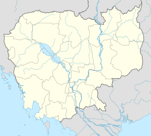
Snuol is a district located in Kratié Province, in Cambodia.
| Snuol | ||
| Khum (Commune) | Phum (Villages) | |
|---|---|---|
| Khsuem | Mil, Choeng, Doung, Khsuem Knong, Khsuem Krau, Samrang, Srae Roneam, Srae Thmei | |
| Pir Thnu | Cheung Khle, Cheung Khlu, Thma Hal Dei Kraham, Pravanh, Thma Hal Veal, Trapeang Srae, Chrab | |
| Snuol | Kat Dai, Kbal Snuol, Krong, Preaek Kdei, Snuol Keat, Thpong, Snuol lech | |
| Srae Char | Roha, Kbal Trach, Mak Kandal, Mean Chey, Treak Anhchanh, S'at | |
| Svay Chreah | Thnal, Voat, Sambuor, Ta Saom, Srae Char, Ta Pum, Doun Mea, Rumpuk | |
| ||||||||||
| ||||||||||
Coordinates: 12°10′N 106°35′E / 12.167°N 106.583°E
This article is issued from Wikipedia. The text is available under the Creative Commons Attribution/Share Alike; additional terms may apply for the media files.
