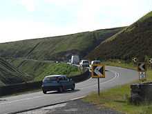
Snake Pass


The Snake Pass is the name given to the remote, higher reaches of the A57 road where it crosses the Peak District between Manchester and Sheffield in Northern England. More specifically, the name usually refers to the section between the town of Glossop and the Ladybower Reservoir, where the road passes over the Pennines watershed between the moorland plateaux of Kinder Scout and Bleaklow (the highest point is 1,680 feet (510 m) above sea level). The Woodhead Pass (A628) is an alternative road route to the Snake Pass linking Manchester and Sheffield.
Like many other A-roads in the North of England that traverse undulating terrain such as the Peak District or other parts of the Pennines, the road has a poor accident record.[1] In winter, the road is often the first of the available routes between Sheffield and Manchester to be closed due to snow in the area. There are areas where the road surface has very poor skid resistance and a number of bends have adverse camber.
Despite Sheffield and Manchester being the fifth and seventh largest UK cities by population respectively, no motorway directly links both cities. The Manchester to Sheffield motorway was partly built, but linking both cities would have meant constructing numerous tunnels and viaducts across the Peak District at a great cost. Consequently, the scheme was shelved.
History
The road was first built as a toll road in 1820 as the most direct route between the two cities. In the 20th century the more northerly route of the Woodhead Pass, which is less steep and at a lower altitude, became the primary road link between Manchester and Sheffield.
The Snake Pass passes through the National Trust's High Peak Estate, and lies within the High Peak borough of Derbyshire. Much of it falls within the Hope Woodlands parish.
Snake Pass was listed as one of best driving roads in the UK by Auto Trader magazine in 2009.[2]
Origins of the name
The name of the road does match its winding route, but actually derives from the emblem of the Snake Inn, one of the few buildings on the high stretch of road. In turn, the pub's name and sign was derived from the serpent on the Cavendish arms of the Duke of Devonshire.[3] In recent times, the Snake Inn was renamed the "Snake Pass Inn", so the inn named the road which became more well known and so then named the inn.
Accident record
Like many roads in the North of England that go through the undulating terrain such as the Peak District, Lake District and other parts of the Pennines, Snake Pass has a poor safety record in comparison to other roads in the United Kingdom. However, Snake Pass is not as dangerous as other roads that bisect hilly terrain in this part of England; it was not among the top 10 in a list of the most dangerous roads published in July 2010, despite nine of the top ten being in Northern England.[4]
On 25 January 2008, a landslip due to heavy rain caused the road to be closed to all traffic between Ladybower and Glossop, although access was still available to local premises and businesses including the Snake Pass Inn.[5] On 11 March 2008, the road opened again, but with temporary traffic lights at the point of the slip restricting traffic to one direction at a time. The repairs were completed in August 2008.
Closures due to inclement weather
Snake Pass is often closed in the winter months as the bending roads become icy and little grit is placed down to combat the problem. The British winter of 2010–11 was one the coldest for decades and the road was closed on numerous occasions.[6][7]
Cycling
Snake Pass is one of only a few road climbs in the UK that are comparable in length and average gradient (approximately 7% for around 3.2 miles (5.1 km) when starting in Glossop) to those used in continental cycle racing. For this reason it has frequently featured in the Tour of Britain along with another nearby favourite, Holme Moss.
Cycling Time Trials sanctioned hill climbs are regularly promoted on this course by local club Glossop Kinder Velo. The course record currently stands at 12 minutes 16 seconds.
Popular culture
Inspiral Carpets filmed their 1990 video for "This Is How It Feels" where the road peaks.
The music track "The Snake" by the Human League, from their 2001 album Secrets, is entirely about the Snake Pass.
The Autechre EP Anvil Vapre features track names deriving from locations around the Snake Pass.
Comedian John Shuttleworth has performed a song called "Incident on Snake Pass" about the perils of driving on the Snake Pass.
References
- ↑ Full Application - Installation of 6.4m Pole-Mounted Antenna - application to install police radio mast 800m west of Snake Pass summit
- ↑ "England's best driving road - revealed". Auto Trader Magazine. 23 April 2009. Retrieved 4 July 2011.
- ↑ Smith, Roly (2008). Peak District: Northern and Western Moors. United Kingdom: Frances Lincoln Ltd. p. 128. ISBN 9780711224995.
- ↑ "'Most dangerous' roads in Britain named by safety group". BBC News. 1 July 2010. Retrieved 4 July 2011.
- ↑ Derbyshire County Council - Snake Pass closed
- ↑ "Derbyshire hit by road and school closures over snow". BBC News. 2 December 2010. Retrieved 9 July 2011. "The A57 Snake Pass is closed in both directions between the Hurst Road junction in Glossop and the A6013."
- ↑ "Snake Pass closed as snow returns". Glossop Advertiser. 17 December 2010. Retrieved 9 July 2011.
External links
| Wikimedia Commons has media related to Snake Pass. |
- National Trust description of the area
- grid reference SK087928
- A Walkover Survey of a Landslide at Cowms Moor, Snake Pass, A57, Derbyshire British Geological Survey
Coordinates: 53°25′58″N 1°52′08″W / 53.4329°N 1.8689°W