Smržovka
| Smržovka | ||
| Town | ||
.jpg) T. G. Masaryk Square | ||
|
||
| Country | Czech Republic | |
|---|---|---|
| Region | Liberec | |
| District | Jablonec nad Nisou | |
| Commune | Tanvald | |
| Elevation | 585 m (1,919 ft) | |
| Coordinates | 50°44′N 15°15′E / 50.733°N 15.250°E | |
| Area | 14.82 km2 (5.72 sq mi) | |
| Population | 3,572 (2012-12-31) | |
| Density | 241 / km2 (624 / sq mi) | |
| First mentioned | 1568 | |
| Mayor | Marek Hotovec | |
| Timezone | CET (UTC+1) | |
| - summer (DST) | CEST (UTC+2) | |
| Postal code | 468 51 | |
  Location in the Czech Republic
| ||
| Statistics: statnisprava.cz | ||
| Website: www.smrzovka.cz | ||
Smržovka (German: Morchenstern) is a town in the Liberec Region, Czech Republic. Name Smržovka was given to town by overgrown mountain forest, where there was a large amount of morels (Czech: Smrž, German: Morcheln).[1]
History


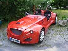
Smržovka was founded in the first half of the 16th century during the colonization of the Jizera Mountains, the first written mention of the village dates from 1568. Until 1918, Smržovka was part of the Austria-Hungary, in the Jablonec nad Nisou (German: Gablonz a.d. Neisse) district, one of the 94 districts in Bohemia.[2] With the development of industry in and around Smržovka, it develops mainly glassworks, grinding shops and weaving and Smržovka in 1849 became the market place. In 1905 was promoted to town. In 1991 there was founded the Kaipan company, a Czech car manufacturer with a focus to the sports roadsters.
Population
| Year | 1833 | 1878 | 1918 | 1970 | 1980 | 1991 | 2001 | 2012 |
|---|---|---|---|---|---|---|---|---|
| Population | 2 550 | 4 551 | c. 7 000 | 3 747 | 3 526 | 3 418 | 3 430 | 3 572 |
Twin towns
References
- ↑ Stručná historie Smržovky
- ↑ Die postalischen Abstempelungen auf den österreichischen Postwertzeichen-Ausgaben 1867, 1883 und 1890, Wilhelm KLEIN, 1967
External links
| Wikimedia Commons has media related to Smržovka. |
