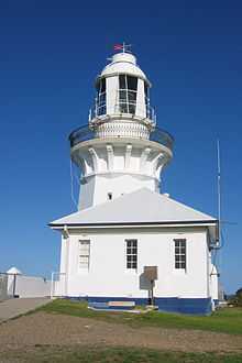
Smoky Cape Lighthouse
 | |
| Smoky Cape Lighthouse, near South West Rocks | |
 | |
| Location | Smoky Cape, New South Wales, Australia |
|---|---|
| Coordinates | 30°55′23″S 153°05′15.73″E / 30.92306°S 153.0877028°ECoordinates: 30°55′23″S 153°05′15.73″E / 30.92306°S 153.0877028°E |
| Year first lit | 1891 |
| Automated | 1988 |
| Construction | Cast concrete |
| Tower shape | Octagonal |
| Markings / pattern | White tower and building |
| Height | 17.4 metres (57 ft) |
| Focal height | 128 metres (420 ft) |
| Original lens | First order Fresnel lens |
| Intensity | 1,000,000 cd |
| Range | 26 nautical miles (48 km; 30 mi)[1] |
| Characteristic | Fl.(3)W. 20s |
| Admiralty number | K2796 |
| NGA number | 6016 |
| ARLHS number | AUS-149 |
Smoky Cape Lighthouse is an active lighthouse located on Smoky Cape, a headland east of the town of South West Rocks, New South Wales, Australia, and within the Hat Head National Park. It directs boats towards the entrance to the Macleay River, which is located just to the north of the lighthouse.[2]
It is one of the last major lighthouse complexes designed by the New South Wales colonial architect of the time, James Barnet,[3] and was one of Australia's last lighthouses to be designed for architectural excellence.[4] Standing on a granite headland 140 metres (460 ft) above the sea, its light is the highest in New South Wales.[5]
History

The lighthouse was first proposed in 1886 to ensure the safety of the increasing coastal traffic on the northern seaboard of New South Wales, and was completed in 1891. The contract to build it was won by William Frank Oakes but he died during construction and the work was completed by his executors.[4] As a result of the Commonwealth Lighthouses Act of 1911, management of the lighthouse was transferred in 1915 to Federal control because of its status as a coastal light.[4]
Since 1939, the lighthouse has been an Australian Bureau of Meteorology site for the gathering of climate statistics.[6]
During the World War 2, the lighthouse precinct was used for military purposes. There was a searchlight battery and light gun emplacement, and possibly a radio room, operating there at that time. The concrete remains of the military installation are still visible.[5]
In 1962 the light was electrified and around 1988 it was automated. The optic system is still the original first order Fresnel lens.[4][7]
On May 14, 1998, Smoky Cape was the first NSW Parks and Wildlife Service lighthouse to be opened for tours.[8]
Design


The lighthouse's design is unusual for its octagonal tower, and was so designed because it was easier to cast the tower in the octagonal formwork than round formwork.[4] It has a single story pavilion entrance, cast iron staircase and distinctive gunmetal balustrade.[9] It is one of only three nineteenth century mass concrete lighthouses in NSW (the others being South Solitary Island Lighthouse and Green Cape Lighthouse).[5] The fact that it has its original Chance Brothers revolving apparatus and lens, and lantern house, makes it an important example of late nineteenth century industrial maritime technology.[5]
Operation and tourism
The lighthouse is operated by the Australian Maritime Safety Authority and is classified by the National Trust of Australia (NSW).
Its nearest lighthouses are South Solitary Island Lighthouse north of Coffs Harbour, to the north, and Tacking Point Lighthouse at Port Macquarie, to the south.
The lighthouse complex is located in Hat Head National Park. The head keeper's cottage is now run as a bed and breakfast,[7] and two other cottages as holiday houses, leased from the NSW National Parks and Wildlife Service.
The cape is a popular point for whale-watching.[citation needed]
See also

Notes
- ↑ According to "Lighthouses of Australia Inc". List of Lights says 25 nautical miles (46 km; 29 mi).
- ↑ Smokey Cape Lighthouse Photo Gallery
- ↑ Searle, Garry. "Smoky Cape". Lighthouses of New South Wales. SeaSide Lights.
- ↑ 4.0 4.1 4.2 4.3 4.4 "Smoky Cape Lighthouse". Lighthouses of New South Wales. Lighthouses of Australia Inc.
- ↑ 5.0 5.1 5.2 5.3 "Smoky Cape Lighthouse (listing CHL105604)". Australia Heritage Places Inventory. Department of Sustainability, Environment, Water, Population and Communities.
- ↑ Climate Statistics for Australian Locations
- ↑ 7.0 7.1 Rowlett, Russ. "Lighthouses of Australia: New South Wales". The Lighthouse Directory. University of North Carolina at Chapel Hill. Retrieved 2 May 2010.
- ↑ Lighthouses of Australia. June 1998 Bulletin
- ↑ Smoky Cape Lighthouse
References
| Wikimedia Commons has media related to Smoky Cape Lighthouse. |
| ||||||||||||||||||||
