Slovenian Littoral
 |
| Carniola: 2a Upper 2b Inner, 2c Lower |
The Slovenian Littoral (Slovene: Primorska, ![]() pronunciation (help·info); Italian: Litorale; German: Küstenland) is one of the five traditional regions of Slovenia. Its name recalls the former Austrian Littoral (Avstrijsko Primorje), the Habsburg possessions on the upper Adriatic coast, which the Slovenian Littoral was part of.
pronunciation (help·info); Italian: Litorale; German: Küstenland) is one of the five traditional regions of Slovenia. Its name recalls the former Austrian Littoral (Avstrijsko Primorje), the Habsburg possessions on the upper Adriatic coast, which the Slovenian Littoral was part of.
Geography
The region forms the westernmost part of Slovenia, bordering with the Italian region of Friuli-Venezia Giulia. It stretches from the Adriatic Sea in the south up to the Julian Alps in the north.
The Slovenian Littoral comprises two traditional provinces: Goriška and Slovenian Istria. The Goriška region takes its name from the town of Gorizia (Slovene: Gorica) now in Italy; the neighbouring conurbation of Nova Gorica and Šempeter-Vrtojba today is the urban centre of the Slovenian Littoral. Slovenian Istria comprises the northern part of the Istria peninsula and provides, on the Slovenian Riviera coastline with the ports of Koper, Izola, and Piran, the country's only access to the sea.
After Ljubljana, the Slovene Littoral is the most developed and economically most prosperous part of Slovenia. The western part of Slovenian Istria is a bilingual region where both Slovene and Italian may be used in education, legal and administrative environments.
The northern part of the Slovenian Littoral is part of the larger Gorizia Statistical Region, the south belongs to the Coastal–Karst Statistical Region.
History

After they had acquired the Carniola hinterland in 1335, the Habsburgs gradually took possession of the coastal areas. In 1500 they inherited the comital lands of Gorizia (Görz), when the last Count Leonhard of Gorizia died childless. The Habsburg Princely County of Gorizia and Gradisca was established in 1754, it became part of the Austrian Kingdom of Illyria in 1816. With the Istrian march and the Imperial Free City of Trieste it was re-arranged as the Austrian Littoral crown land in 1849.
At the end of World War I and the dissolution of Austria–Hungary in 1918, the area, together with the western part of Inner Carniola and the Upper Carniolan municipality of Bela Peč/Weissenfels (later Italianized to Fusine in Valromana, now a frazione of Tarvisio), was occupied by the Italian army. As stipulated in the 1915 London Pact, a quarter of predominantly Slovene ethnic territory and approximately 327.000[2] out of total population of 1.3[1] million Slovenes was adjudicated to Italy by the 1919 Treaty of Saint-Germain and finally annexed according to the 1920 border Treaty of Rapallo.
Incorporated into the Julian March (Venezia Giulia) a forced Italianization of the Slovene minority began, intensified after the Fascists under Benito Mussolini came to power in 1922, and lasted until 1943. The Slovenes in Italy lacked any minority protection under international or domestic law.[3] Numerous Slovenes emigrated to the Kingdom of Yugoslavia, others fought against Italian occupation in the anti-fascist TIGR organization.
After World War II, according to the 1947 Paris Peace Treaties, the bulk of the region with the upper Soča (Isonzo) Valley fell to Yugoslavia. Parts of the area were re-arranged as the Free Territory of Trieste, while Italy retained the urban centres of Gorizia and Gradisca. In 1954 also recovered the main port of Trieste. As a result, the new urban centres on the Slovenian side of the border developed.
Photo gallery
-

Mount Krn in the Julian Alps
-

Kozjak Falls in the Soča (or Isonzo) Valley
-

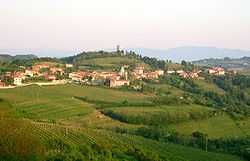
The Brda wine region
-

The town of Nova Gorica
-
The Nanos plateau rising above the Vipava Valley
-

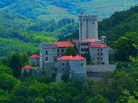
Rihemberk Castle near Branik
-
Rural architecture on the Karst Plateau
-
A sheep herd on the Karst Plateau
-

Landscape in Slovenian Istria
-

The Adriatic town of Piran
-

The Praetorian Palace in Koper
See also
- Battles of the Isonzo
- Morgan Line
- Treaty of Osimo
- Kras
- Vipava Valley
- Soča
- Slovenian wine
- Venetian Slovenia
References
- ↑ 1.0 1.1 Lipušček, U. (2012) Sacro egoismo: Slovenci v krempljih tajnega londonskega pakta 1915, Cankarjeva založba, Ljubljana. ISBN 978-961-231-871-0
- ↑ 2.0 2.1 Cresciani, Gianfranco (2004) Clash of civilisations, Italian Historical Society Journal, Vol.12, No.2, p.4
- ↑ Hehn, Paul N. (2005). A Low Dishonest Decade: The Great Powers, Eastern Europe, and the Economic Origins of World War II, 1930–1941. Continuum International Publishing Group. pp. 44–45. ISBN 0-8264-1761-2.
Coordinates: 45°59′21.58″N 13°48′35.33″E / 45.9893278°N 13.8098139°E


.jpg)