Slea Head
From Wikipedia, the free encyclopedia
Coordinates: 52°6.37′N 10°28.15′W / 52.10617°N 10.46917°W

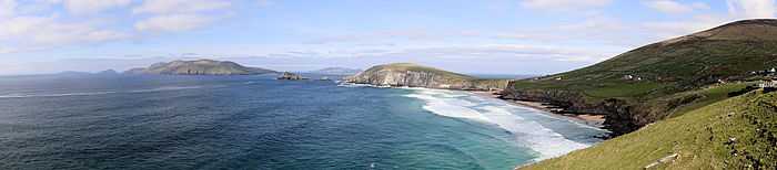
Slea Head is the promontory in the back to the right in this photo, taken from the very end of Dunmore Head, the westernmost point of Ireland.
Slea Head (Irish: Ceann Sléibhe[1]) is a promontory in the westernmost part of the Dingle Peninsula, located in the barony of Corca Dhuibhne in southwest County Kerry, Ireland. It belongs to Munster's province (County Kerry) and is served by the R559 road; the nearest villages are Ballyickeen and Coumeenoole.
It is a well known and recognised landmark and also a very scenic viewpoint, with a dramatic view of the Blasket Islands.[2] On the 11 March 1982, the Spanish container ship, Ranga, was wrecked at Dunmore head, close to Slea Head after losing power in a storm.
A view of Blasket Islands and Dunmore Head from Slea Head.
References
- ↑ "Ceann Sléibhe". Placenames Database of Ireland. Retrieved 1 October 2010.
- ↑ "Dingle Peninsula". Discover Ireland. Retrieved 1 October 2010.
This article is issued from Wikipedia. The text is available under the Creative Commons Attribution/Share Alike; additional terms may apply for the media files.