Skilak Lake
From Wikipedia, the free encyclopedia
| Skilak Lake | |
|---|---|
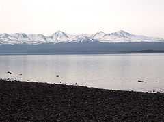
 from the beach at lower Skilak campground, Frying Pan Island is visible at lower right | |
| Location | Kenai Peninsula, Alaska |
| Coordinates | 60°24′59″N 150°20′02″W / 60.41639°N 150.33389°WCoordinates: 60°24′59″N 150°20′02″W / 60.41639°N 150.33389°W |
| Primary inflows | Kenai River |
| Primary outflows | Kenai River |
| Basin countries | United States |
| Max. length | 15 mi (24 km) |
| Max. depth | 528 ft (161 m) |
| Frozen | late Nov.- late April |
| Islands | Frying Pan Island, Caribou Island |

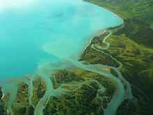
The turquoise water of Skilak Lake, as seen from the air
See also
References

The lake seen from Skilak Lake Road
- ↑ U.S. Geological Survey Geographic Names Information System: Skilak Lake
- ↑ The Milepost, 59th edition, page 588. ISBN 9781892154217
External links
| |||||||||||
This article is issued from Wikipedia. The text is available under the Creative Commons Attribution/Share Alike; additional terms may apply for the media files.