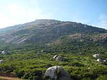
Skandagiri
Skandagiri, also known as Kalavara Durga, is an ancient mountain fortress located approximately 70 km from Bangalore city, and 3 km from Chikballapur in the Indian state of Karnataka. It is off Bellary Road ( NH 7 Hyderabad-Bangalore Highway), and overlooks Nandi Hills, Muddenahalli, and Kanivenarayanapura. The peak is at an altitude of about 1350 meters.

About
| Altitude | About 1350 meters above sea level |
| Distance | 70 km from Bangalore |
| Nearest Town/Medical Help | Chikballapur, 5 km |
| Nearest Airport/ Railway station | Devanahalli (Bangaluru International Airport) |
| Co-ordinates | 13°25′3″N 77°40′58″E |
Papagni mutt
One of the ancient and oldest mutt of karnataka "Papagni mutt" is located at skandagiri hills. This mutt is considered to be one of the rare in its kind as it is believed that devotees sitting inside the temple premises, can feel the devotial vibrations. Special poojas are performed every Saturday.


Getting there
There are two routes to Skandagiri:
- From NH 7, turn towards Nandi Hills. At the base of Nandi Hills turn right and proceed to Kalawara village via Muddenahalli (birthplace of Bharath Rathna Sir M Visvesvarayya).
- From Chikballapur proceed directly to Kalawara village
Directions:
- Follow the Bangalore International Airport, better known as Bellary Road (NH 7). After crossing BIA take the diversion to Chikballapur. You can see the board for Chikballapur on NH 7 easily. Follow the same road for about 7–8 km until you find a Visvesvarayya statue to your Left. Note that this is a small bust and is easy to miss. There is also a small Ganesha temple right next to that left turn.
- Take a left at this place and a right turn at the City Municipal Council a little further down. Later this shall directly lead to Papagni Mutt, which is the base of
Trekking
Level of Trekking : Moderately difficult
Must carry water, first aid box, snacks or light foods.Its gets quite hot at the top , so no need to carry heavy clothing. Local villagers camp on the peak and sell omelettes, cold drinks, tea, and other refreshments. They even gather wood for you in case you want a campfire and can serve as guides over the terrain.
It is common to trek in the dark, and it's a lot fun on a beautiful full moon night. Trekkers usually start climbing at around 2:00 AM and aim to reach the top by around 5:00 AM to catch the sunrise. You must carry one torch per person if planning a night trek. Sometimes the night trek is banned because of security reasons. One must ensure that the night trek is available prior to trekking. Mid of December to second week of January is the best time to visit scandagiri and witness the beautiful scene of Sun rising over white bed of clouds under you.
This is a moderately difficult trek as the hill is precipitous and high. The trek starts from the Papagni Temple at the foot of the hill. The fortress is in full sight throughout the trek uphill. This steep and fantastic trek through a maze of dense shrub is highly intriguing. Skandagiri is a teaser. Just as you reach the fort wall content that you have topped the hill, you see another ring of fort. There are six such series of stonewalls protecting an abandoned ancient temple on the hilltop. The trek is approximately 8 km and takes around 1.5 – 3 hours to climb depending upon your level of fitness.
If you are a geologist and interested in doing some study on the trip, there are a few very old stone sculptures of Hindu deities about 100m before the base camp across a temple. Villagers have also built a modern temple right across the road.
Don't forget to carry your camera to take breathtaking pictures of 360 degree view of surroundings. You can also see Nandi Hills from here.
Important information
As of December 2011, Skandagiri trekking has been completely banned by Chickballapur police, during night as well as day. All the local guides have been warned as well. Police are very serious about the ban after a recent case of death of a person while trekking. Any attempt of trekking would end you up in the Chickballapur police station along with your vehicle.
Police guard the base of the hill and they have set up some locals as well to catch anyone who attempts a trek.
The reasons cited by the police for the ban are:
- Some stretches of the hill are very slippery and could be fatal.
- Danger from wild animals.
- Some scenarios wherein the locals show you the wrong way, as they are not paid for their services, which could lead you to danger.
- Lack of any medical help nearby.
As of January 2013, day trekking is allowed. Most of the trail has been marked with guiding arrows which if followed, leads to a safe route to hill top. Guides are available near the temple. Parking can be done beside the village near the temple.
References
Coordinates: 13°25′03″N 77°40′58″E / 13.41750°N 77.68278°E