Skógar
| Skógar | |
|---|---|
| Village | |
 | |
 | |
 Skógar | |
| Coordinates: 63°31′N 19°30′W / 63.517°N 19.500°W | |
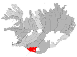
| Country | Iceland |
| Constituency[1] | Suðurkjördæmi |
| Region[2] | Suðurland |
| County | Rangárvallasýsla |
| Municipality | Rangárþing eystra |
| Population | |
| • Total | 25 |
| Time zone | GMT (UTC+0) |
Skógar (pronounced [ˈskou.ar] (![]() )), literally forests, is a small Icelandic village with a population of roughly 25 located at the south of the Eyjafjallajökull glacier, in the municipality of Rangárþing eystra.
)), literally forests, is a small Icelandic village with a population of roughly 25 located at the south of the Eyjafjallajökull glacier, in the municipality of Rangárþing eystra.
The area is known for its waterfall, Skógafoss, on the Skógá river, which springs from 60 metres at the top of an eroded cliff. At Skógar is a folk museum, Skógasafn, open daily, all the year, as well as a museum on transport in Iceland.
Not far from Skógar is the Kvernufoss fall. Further upstream on the Skógá river there are many other spectacular falls. While climbing in the small forest behind the old school, some ruins of old farms can be seen and easily accessed.
This town was highly affected by the eruption of the Eyjafjalla volcano in 2010.
Gallery
-
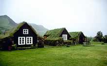
Museum of Skógar
-
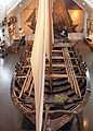
Pétursey, fishing boat at the museum
-
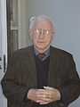
Þórður Tómasson, founder of the museum
See also
- List of settlements in Iceland
- Waterfalls of Iceland
References
External links
| Wikimedia Commons has media related to Skógar. |
Coordinates: 63°31′29″N 19°30′25″W / 63.52472°N 19.50694°W