Sjöbo Municipality
| Sjöbo Municipality Sjöbo kommun | ||
|---|---|---|
| Municipality | ||
| ||
 | ||
| Country | Sweden | |
| County | Skåne County | |
| Seat | Sjöbo | |
| Area[1] | ||
| • Total | 509.23 km2 (196.61 sq mi) | |
| • Land | 495.65 km2 (191.37 sq mi) | |
| • Water | 13.58 km2 (5.24 sq mi) | |
| Area as of January 1, 2010. | ||
| Population (June 30, 2012)[2] | ||
| • Total | 18,118 | |
| • Density | 36/km2 (92/sq mi) | |
| Time zone | CET (UTC+1) | |
| • Summer (DST) | CEST (UTC+2) | |
| ISO 3166 code | SE | |
| Province | Scania | |
| Municipal code | 1265 | |
| Website | www.sjobo.se | |
Sjöbo Municipality (Sjöbo kommun) is a municipality in Skåne County in southern Sweden. Its seat is located in the town Sjöbo.
The present municipality was created in 1974 when the former market town (köping) Sjöbo was amalgamated with the surrounding rural municipalities. There are fifteen original entities within today's municipality.
Localities
There are 9 urban areas (also called a Tätort or locality) in Sjöbo Municipality.
In the table they are listed according to the size of the population as of December 31, 2005. The municipal seat is in bold characters.
| # | Locality | Population |
|---|---|---|
| 1 | Sjöbo | 6,364 |
| 2 | Blentarp | 1,144 |
| 3 | Vollsjö | 788 |
| 4 | Lövestad | 608 |
| 4 | Sjöbo sommarby och Svansjö sommarby | 608 |
| 6 | Karups sommarby | 316 |
| 7 | Bjärsjölagård | 311 |
| 8 | Sövde | 301 |
| 9 | Äsperöd | 226 |
Refugee controversy
Sjöbo Municipality reached the public eye in Sweden in 1988 when, under the leadership of the Municipal Commissioner Sven-Olle Olsson, it voted by a majority of 67% in a referendum that it would not accept foreign asylum seekers. Most other municipalities in Sweden accepted refugees that came from troubled countries such as former Yugoslavia and Iraq.[citation needed]
In the late 1980s and early 1990s, immigration, high unemployment and the fiscal burdens on local governments who were obliged to integrate refugees, and the influence of Sjöbo Municipality's refusal to accept refugees in 1987, led to the adoption of a combined immigration and integration system in the "Aliens Act" of 1989.[3]


Geography
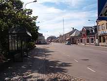
The town of Sjöbo has flat terrain, with many small houses and three long straight streets stretching through it, leading to larger roads.
The northwestern part of the municipality includes the main part of Vombsjön, the largest lake of southern Scania and notable for being the water source of Malmö. Some parts of the lake belong to Lund Municipality. It offers fishing for European perch, pike, pikeperch and eel.[citation needed]
Activities
There are at least five (largely) authentic medieval churches from the 12th century in the municipality (in Södra Åsum, Tolånga, Björka, Blentarp and Everlöv). They are notable for not having undergone the severe restorations that many other churches in Scania suffered once the population began growing in the second half of the 19th century and Helgo Zetterwall was hired to expand on them.
Frescos which adorned the apse of Södra Åsum church and the ceilings of the churches in Everlöv and Illstrop centuries ago have been slowly uncovered in recent years. Many similar churches had their ornamentation stripped and their paintings plastered over as part of the iconoclasm of Sweden's adoption of Lutheranism.
Apart from religious activities, there is the annual festival Sjöbo marknad, which translates to English as Sjöbo fair. It was first held in 1864, and is now held in late July, attracting some 100,000 visitors, making it one of the largest country fairs in Sweden. It has carousels and is otherwise noted for its pottery vendors and trade.[citation needed]
References
- ↑ "Statistiska centralbyrån den 1 januari 2010" (Microsoft Excel) (in Swedish). Statistics Sweden. Retrieved 2010-08-21.
- ↑ "SCB, Befolkningsstatistik 30 juni 2012" (in Swedish). Statistics Sweden. Retrieved 2010-08-19.
- ↑ from Migration News, in what looks to be a review on the book Mechanisms of Immigration Control. A Comparative Analysis of European Regulation Policies, by Brochmann, Grete and Tomas Hammar. (Eds. 1999) Berg Publishers (http://www.berg.demon.co.uk/)
- Statistics Sweden
- Info about Sjöbo Refugee question from a Nationalistic website: Sweden the extreme Way
- Geography & Activities: Tourist broshure Sjöbo Kommun, (2005), available at the tourist office in Swedish, English and German.
External links
- Sjöbo - Official site
- Coat of arms
| ||||||||||||||
| |||||
Coordinates: 55°42′N 13°12′E / 55.700°N 13.200°E
| Wikimedia Commons has media related to Sjöbo Municipality. |
