Sixt-Fer-à-Cheval
| Sixt-Fer-à-Cheval | |
|---|---|
 | |
 Sixt-Fer-à-Cheval | |
|
Location within Rhône-Alpes region  Sixt-Fer-à-Cheval | |
| Coordinates: 46°03′21″N 6°46′35″E / 46.0558°N 6.7764°ECoordinates: 46°03′21″N 6°46′35″E / 46.0558°N 6.7764°E | |
| Country | France |
| Region | Rhône-Alpes |
| Department | Haute-Savoie |
| Arrondissement | Bonneville |
| Canton | Samoëns |
| Government | |
| • Mayor (2008-2014) | Stephane Bouvet |
| Area | |
| • Land1 | 119.07 km2 (45.97 sq mi) |
| Population (2004) | |
| • Population2 | 793 |
| • Population2 Density | 6.7/km2 (17/sq mi) |
| INSEE/Postal code | 74273 / 74740 |
| Elevation | 728–3,099 m (2,388–10,167 ft) |
| Website | http://www.sixtferacheval.com |
|
1 French Land Register data, which excludes lakes, ponds, glaciers > 1 km² (0.386 sq mi or 247 acres) and river estuaries. 2 Population without double counting: residents of multiple communes (e.g., students and military personnel) only counted once. | |
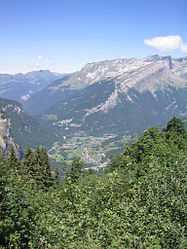
Sixt-Fer-à-Cheval is a municipality in the Haute-Savoie department in the Rhône-Alpes region in southeastern France.
Sixt-Fer-a-Cheval is one of Les Plus Beaux Villages de France. Although the Cirque du Fer à Cheval has made Sixt famous, other attractions include the Cascade du Rouget waterfall, named "Queen of the Alps" and a nature reserve that covers most of the district. Its architectural heritage is shown by the priory and church stemming from the former Sixt Abbey, founded by Ponce de Faucigny.
Geography
The area of the town ranges in altitude from 728 to 3,098 metres (2,388 to 10,164 ft); three-quarters of its area (9200 hectares out of 11200 in total) are part of a natural reserve and completely uninhabited.
The name Sixt-Fer-à-Cheval comes from the shape of the natural amphitheatre ("Cirque du Fer a Cheval") which, from above, looks like a horseshoe. Located in the Natural Reserve of Sixt, the Cirque du Fer a Cheval, classified a Grand-Site de France is a favored destination for 500,000 visitors each year.
The heart of the village is the parish of the Abbaye. Sixt is divided into 12 parishes, along the two main rivers called Giffre des Fonts also called "Giffre-Haut" (Upper Giffre), and Giffre du Fer a Cheval. The Giffre river, a tributary of the Arve, has its source in Sixt-Fer-à-Cheval, coming from a few hundred waterfalls in the nearby mountains.
Four of the twelve parishes are located between the parish of the Abbaye and the Cirque du Fer a Cheval (Les Curtets, L'Echarny, Le Molliet, Nambride). The seven other parishes are located between the parish of the Abbaye and the Rouget Waterfall, in the upper Giffre valley (Maison Neuve, Salvagny, Passy, Le Fay, Hauterive, La Chapelle, and Englène). Sixt-Fer-à-Cheval is linked to the Samoens' valley through one sole road.
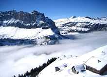
The highest mountain in the village, the Mont Buet (also called "Women's Mont Blanc") reaches 3,099m. Sixt shares important borders with Switzerland (on the northeast) and also Chamonix Mont Blanc (to the south). The village and its 11,200 hectares is recognized as one of Les Plus Beaux Villages de France (The Most Beautiful Villages of France),[1] of which there are only five in all of the French Alps.

LOLLYPOP
Sightseeing
Sixt is a very small village, but its potential and resources are huge. The Rouget-Waterfall (Cascade du Rouget), the Sauffaz-Waterfall (Cascade de la Sauffaz), and the Crying-Waterfall (Cascade de la Pleureuse) are classified among the "Sightseeings of France" list. Two natural mountain amphitheatres (Cirque du Fer a Cheval and Cirque des Fonds) were created during the Alps' birth and carved by the water throughout the last thousands years.
The village has has many religious monuments reflecting the importance of faith to the locals over the centuries. Sixt Church dating from the 13th century (Église Sainte-Madeleine du XIIIe siècle) and the Abbaye are the two monuments located in the heart of Sixt. In addition to these impressive buildings, hundreds of crosses, oratories, and chapels are spread all over Sixt territory. Crosses were initially placed where a potential danger could arise from the nature (rocks falling, avalanches, etc.). Chapels had been built with the aim of giving access to religion to people located in parishes other than one in the centre of the village, the parish of the Abbaye.
Two high altitude lakes in the natural reserve (Anterne's Lake, Vogealle's Lake) are accessible by foot.
There are also mountain huts, accessible in summer after short to long walks (depending the place) where you can rest for a couple of nights or just have a meal/drink. These mountains huts are placed in strategic areas in Sixt and offer a high quality service for a very reasonable price.
See also
References
External links
| Wikimedia Commons has media related to Sixt-Iron Horse. |
| Wikimedia Commons has media related to Haute-Savoie. |